


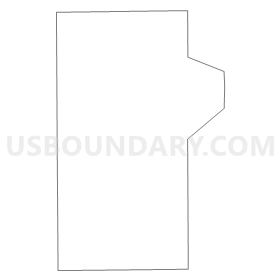
DE014, Marion County, Indiana
About
Outline
Summary
| Unique Area Identifier | 579240 |
| Name | DE014 |
| County | Marion County |
| State | Indiana |
| Area (square miles) | 2.21 |
| Land Area (square miles) | 2.21 |
| Water Area (square miles) | 0.00 |
| % of Land Area | 100.00 |
| % of Water Area | 0.00 |
| Latitude of the Internal Point | 39.64769030 |
| Longtitude of the Internal Point | -86.29711360 |
Maps


Graphs
Select a template below for downloading or customizing gragh for DE014, Marion County, Indiana


Neighbors
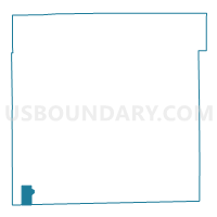
Neighoring Voting District (by Name) Neighboring Voting District on the Map
- DE009, Marion County, IN
- DE010, Marion County, IN
- DE013, Marion County, IN
- DE015, Marion County, IN
- MADISON 03, Morgan County, IN
- MADISON 06, Morgan County, IN
Top 10 Neighboring County Subdivision (by Population) Neighboring County Subdivision on the Map
Top 10 Neighboring Place (by Population) Neighboring Place on the Map
Top 10 Neighboring Unified School District (by Population) Neighboring Unified School District on the Map
- Decatur Township Metropolitan School District, IN (32,388)
- Mooresville Consolidated School Corporation, IN (24,200)