


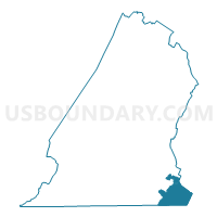
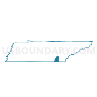
050 Apison 1 Voting District, Hamilton County, Tennessee
About
Outline

Summary
| Unique Area Identifier | 668629 |
| Name | 050 Apison 1 Voting District |
| County | Hamilton County |
| State | Tennessee |
| Area (square miles) | 16.18 |
| Land Area (square miles) | 16.18 |
| Water Area (square miles) | 0.01 |
| % of Land Area | 99.97 |
| % of Water Area | 0.03 |
| Latitude of the Internal Point | 35.00485400 |
| Longtitude of the Internal Point | -85.00967560 |
Maps

Graphs
Select a template below for downloading or customizing gragh for 050 Apison 1 Voting District, Hamilton County, Tennessee


Neighbors
Neighoring Voting District (by Name) Neighboring Voting District on the Map
- 047CAKT - CATOOSA KEITH Voting District, Catoosa County, GA
- 052 Collegedale 1 Voting District, Hamilton County, TN
- 060 Ooltewah 1 Voting District, Hamilton County, TN
- 118 Apison 2 Voting District, Hamilton County, TN
- 313CO - COHUTTA Voting District, Whitfield County, GA
- 602-1 Blue Spring Voting District, Bradley County, TN
- 604-1 Black Fox Voting District, Bradley County, TN
Top 10 Neighboring County Subdivision (by Population) Neighboring County Subdivision on the Map
- District 9, Hamilton County, TN (44,522)
- District 6, Bradley County, TN (14,597)
- North Whitfield CCD, Whitfield County, GA (12,508)
- Catoosa Springs CCD, Catoosa County, GA (6,955)
Top 10 Neighboring Place (by Population) Neighboring Place on the Map
Top 10 Neighboring Unified School District (by Population) Neighboring Unified School District on the Map
- Hamilton County School District, TN (336,463)
- Whitfield County School District, GA (69,608)
- Catoosa County School District, GA (63,942)
- Bradley County School District, TN (57,678)
Top 10 Neighboring State Legislative District Lower Chamber (by Population) Neighboring State Legislative District Lower Chamber on the Map
- State House District 22, TN (64,839)
- State House District 26, TN (64,600)
- State House District 30, TN (64,427)
- State House District 6, GA (53,746)
Top 10 Neighboring State Legislative District Upper Chamber (by Population) Neighboring State Legislative District Upper Chamber on the Map
- State Senate District 11, TN (188,547)
- State Senate District 9, TN (179,807)
- State Senate District 54, GA (173,407)
Top 10 Neighboring 111th Congressional District (by Population) Neighboring 111th Congressional District on the Map
Top 10 Neighboring Census Tract (by Population) Neighboring Census Tract on the Map
- Census Tract 1.02, Whitfield County, GA (8,441)
- Census Tract 115, Bradley County, TN (7,743)
- Census Tract 301, Catoosa County, GA (6,955)
- Census Tract 112.03, Hamilton County, TN (6,235)
- Census Tract 112.04, Hamilton County, TN (5,055)
Top 10 Neighboring 5-Digit ZIP Code Tabulation Area (by Population) Neighboring 5-Digit ZIP Code Tabulation Area on the Map
- 30736, GA (41,029)
- 37363, TN (32,244)
- 37311, TN (27,373)
- 30710, GA (6,661)
- 37353, TN (4,513)
- 37302, TN (3,730)