


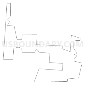
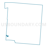
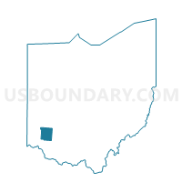
0150 DEF-T-WA Voting District, Warren County, Ohio
About
Outline
Summary
| Unique Area Identifier | 653086 |
| Name | 0150 DEF-T-WA Voting District |
| County | Warren County |
| State | Ohio |
| Area (square miles) | 0.47 |
| Land Area (square miles) | 0.47 |
| Water Area (square miles) | 0.00 |
| % of Land Area | 100.00 |
| % of Water Area | 0.00 |
| Latitude of the Internal Point | 39.32326430 |
| Longtitude of the Internal Point | -84.33305300 |
Maps

Graphs
Select a template below for downloading or customizing gragh for 0150 DEF-T-WA Voting District, Warren County, Ohio


Neighbors
Neighoring Voting District (by Name) Neighboring Voting District on the Map
- 0022 MAS-C-M Voting District, Warren County, OH
- 0044 DEF-T-SW Voting District, Warren County, OH
- 0133 DEF-T-SWC Voting District, Warren County, OH
- 0143 DEF-T-WMC Voting District, Warren County, OH
- 0161 DEF-T-SWD Voting District, Warren County, OH
- WEST CHESTER TWP WC3 Voting District, Butler County, OH
- WEST CHESTER TWP WC40 Voting District, Butler County, OH
- WEST CHESTER TWP WC5 Voting District, Butler County, OH
Top 10 Neighboring County Subdivision (by Population) Neighboring County Subdivision on the Map
- West Chester township, Butler County, OH (60,958)
- Deerfield township, Warren County, OH (36,059)
- Mason city, Warren County, OH (30,712)
Top 10 Neighboring Place (by Population) Neighboring Place on the Map
Top 10 Neighboring Unified School District (by Population) Neighboring Unified School District on the Map
- Lakota Local School District, OH (93,820)
- Mason City School District, OH (48,732)
- Kings Local School District, OH (24,764)
Top 10 Neighboring State Legislative District Lower Chamber (by Population) Neighboring State Legislative District Lower Chamber on the Map
Top 10 Neighboring State Legislative District Upper Chamber (by Population) Neighboring State Legislative District Upper Chamber on the Map
Top 10 Neighboring 111th Congressional District (by Population) Neighboring 111th Congressional District on the Map
Top 10 Neighboring Census Tract (by Population) Neighboring Census Tract on the Map
- Census Tract 320.05, Warren County, OH (9,434)
- Census Tract 319.04, Warren County, OH (6,749)
- Census Tract 111.11, Butler County, OH (6,730)
- Census Tract 320.04, Warren County, OH (6,229)