


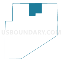
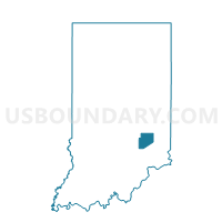
CLINTON TOWNSHIP, Decatur County, Indiana
About
Outline

Summary
| Unique Area Identifier | 576820 |
| Name | CLINTON TOWNSHIP |
| County | Decatur County |
| State | Indiana |
| Area (square miles) | 22.47 |
| Land Area (square miles) | 22.47 |
| Water Area (square miles) | 0.00 |
| % of Land Area | 100.00 |
| % of Water Area | 0.00 |
| Latitude of the Internal Point | 39.42006650 |
| Longtitude of the Internal Point | -85.46349420 |
Maps

Graphs
Select a template below for downloading or customizing gragh for CLINTON TOWNSHIP, Decatur County, Indiana


Neighbors
Neighoring Voting District (by Name) Neighboring Voting District on the Map
- ADAMS TOWNSHIP, Decatur County, IN
- ANDERSON 14, Rush County, IN
- FUGIT TOWNSHIP, Decatur County, IN
- WASHINGTON TOWNSHIP, Decatur County, IN
Top 10 Neighboring County Subdivision (by Population) Neighboring County Subdivision on the Map
- Washington township, Decatur County, IN (13,304)
- Adams township, Decatur County, IN (1,944)
- Fugit township, Decatur County, IN (1,767)
- Anderson township, Rush County, IN (1,251)
- Clinton township, Decatur County, IN (513)
Top 10 Neighboring Unified School District (by Population) Neighboring Unified School District on the Map
- Rush County Schools, IN (15,236)
- Greensburg Community Schools, IN (14,078)
- Decatur County Community Schools, IN (11,983)
Top 10 Neighboring State Legislative District Lower Chamber (by Population) Neighboring State Legislative District Lower Chamber on the Map
Top 10 Neighboring State Legislative District Upper Chamber (by Population) Neighboring State Legislative District Upper Chamber on the Map
Top 10 Neighboring 111th Congressional District (by Population) Neighboring 111th Congressional District on the Map
Top 10 Neighboring Census Tract (by Population) Neighboring Census Tract on the Map
- Census Tract 9690, Decatur County, IN (4,977)
- Census Tract 9692, Decatur County, IN (4,873)
- Census Tract 9745, Rush County, IN (4,171)
- Census Tract 9741, Rush County, IN (3,078)