


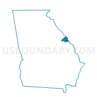
245803 - 803 Voting District, Richmond County, Georgia
About
Outline

Summary
| Unique Area Identifier | 562802 |
| Name | 245803 - 803 Voting District |
| County | Richmond County |
| State | Georgia |
| Area (square miles) | 63.05 |
| Land Area (square miles) | 62.68 |
| Water Area (square miles) | 0.37 |
| % of Land Area | 99.41 |
| % of Water Area | 0.59 |
| Latitude of the Internal Point | 33.35536600 |
| Longtitude of the Internal Point | -82.22621810 |
Maps


Graphs
Select a template below for downloading or customizing gragh for 245803 - 803 Voting District, Richmond County, Georgia


Neighbors
Neighoring Voting District (by Name) Neighboring Voting District on the Map
- 073021 - HARLEM BAPTIST Voting District, Columbia County, GA
- 073030 - GROVETOWN CITY Voting District, Columbia County, GA
- 1630081 - WRENS Voting District, Jefferson County, GA
- 189133B - DEARING GYM Voting District, McDuffie County, GA
- 245304 - 304 Voting District, Richmond County, GA
- 245310 - 310 Voting District, Richmond County, GA
- 245407 - 407 Voting District, Richmond County, GA
- 245801 - 801 Voting District, Richmond County, GA
- 245801B - 801B Voting District, Richmond County, GA
- 245804 - 804 Voting District, Richmond County, GA
- 245807 - 807 Voting District, Richmond County, GA
Top 10 Neighboring County Subdivision (by Population) Neighboring County Subdivision on the Map
- Augusta CCD, Richmond County, GA (134,777)
- Gracewood CCD, Richmond County, GA (36,162)
- Grovetown-Harlem CCD, Columbia County, GA (26,306)
- Hephzibah CCD, Richmond County, GA (20,618)
- Fort Gordon CCD, Richmond County, GA (8,992)
- Dearing CCD, McDuffie County, GA (5,260)
- Wrens CCD, Jefferson County, GA (5,179)
Top 10 Neighboring Place (by Population) Neighboring Place on the Map
Top 10 Neighboring Unified School District (by Population) Neighboring Unified School District on the Map
- Richmond County School District, GA (200,549)
- Columbia County School District, GA (124,053)
- Mcduffie County School District, GA (21,875)
- Jefferson County School District, GA (16,930)
Top 10 Neighboring State Legislative District Lower Chamber (by Population) Neighboring State Legislative District Lower Chamber on the Map
- State House District 117, GA (64,224)
- State House District 120, GA (49,471)
- State House District 123, GA (49,250)
- State House District 124, GA (45,898)
- State House District 122, GA (45,723)
- State House District 142, GA (45,637)
Top 10 Neighboring State Legislative District Upper Chamber (by Population) Neighboring State Legislative District Upper Chamber on the Map
- State Senate District 24, GA (182,334)
- State Senate District 23, GA (153,242)
- State Senate District 22, GA (138,542)
Top 10 Neighboring 111th Congressional District (by Population) Neighboring 111th Congressional District on the Map
Top 10 Neighboring Census Tract (by Population) Neighboring Census Tract on the Map
- Census Tract 102.04, Richmond County, GA (13,436)
- Census Tract 305.06, Columbia County, GA (10,720)
- Census Tract 108, Richmond County, GA (8,992)
- Census Tract 305.03, Columbia County, GA (6,751)
- Census Tract 9505, McDuffie County, GA (5,260)
- Census Tract 9601, Jefferson County, GA (5,179)
- Census Tract 109.03, Richmond County, GA (5,141)
- Census Tract 109.04, Richmond County, GA (3,726)
- Census Tract 107.11, Richmond County, GA (3,370)
- Census Tract 107.07, Richmond County, GA (3,039)
Top 10 Neighboring 5-Digit ZIP Code Tabulation Area (by Population) Neighboring 5-Digit ZIP Code Tabulation Area on the Map
- 30909, GA (41,585)
- 30815, GA (39,640)
- 30813, GA (30,415)
- 30905, GA (8,955)
- 30814, GA (8,150)
- 30808, GA (4,615)
- 30805, GA (2,734)
- 30818, GA (555)