


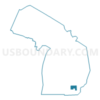
State Senate District 18, Michigan
About

** Data sources from census 2010 **
Maps


Graphs


Neighbors
Neighoring State Legislative District Upper Chamber (by Name) Neighboring State Legislative District Upper Chamber on the Map
- State Senate District 15, MI
- State Senate District 17, MI
- State Senate District 19, MI
- State Senate District 22, MI
- State Senate District 7, MI
Top 10 Neighboring County (by Population) Neighboring County on the Map
- Wayne County, MI (1,820,584)
- Oakland County, MI (1,202,362)
- Washtenaw County, MI (344,791)
- Livingston County, MI (180,967)
- Jackson County, MI (160,248)
- Monroe County, MI (152,021)
Top 10 Neighboring County Subdivision (by Population) Neighboring County Subdivision on the Map
- Ann Arbor city, Washtenaw County, MI (113,934)
- Canton charter township, Wayne County, MI (90,173)
- Novi city, Oakland County, MI (55,224)
- Ypsilanti charter township, Washtenaw County, MI (53,362)
- Pittsfield charter township, Washtenaw County, MI (34,663)
- Van Buren charter township, Wayne County, MI (28,821)
- Northville township, Wayne County, MI (28,497)
- Plymouth charter township, Wayne County, MI (27,524)
- Hamburg township, Livingston County, MI (21,165)
- Scio township, Washtenaw County, MI (20,081)
Top 10 Neighboring Place (by Population) Neighboring Place on the Map
- Ann Arbor city, MI (113,934)
- Novi city, MI (55,224)
- Ypsilanti city, MI (19,435)
- South Lyon city, MI (11,327)
- Whitmore Lake CDP, MI (6,423)
- Chelsea city, MI (4,944)
- Dexter village, MI (4,067)
- Manchester village, MI (2,091)
- Barton Hills village, MI (294)
Top 10 Neighboring Unified School District (by Population) Neighboring Unified School District on the Map
- Ann Arbor Public Schools, MI (163,782)
- Plymouth-Canton Community Schools, MI (121,658)
- Van Buren Public Schools, MI (47,817)
- South Lyon Community Schools, MI (40,489)
- Ypsilanti School District, MI (38,810)
- Northville Public Schools, MI (37,504)
- Lincoln Consolidated School District, MI (30,904)
- Saline Area Schools, MI (26,376)
- Pinckney Community Schools, MI (26,031)
- Dexter Community School District, MI (19,591)
Top 10 Neighboring State Legislative District Lower Chamber (by Population) Neighboring State Legislative District Lower Chamber on the Map
- State House District 21, MI (110,142)
- State House District 38, MI (105,003)
- State House District 52, MI (104,679)
- State House District 55, MI (104,306)
- State House District 66, MI (100,216)
- State House District 20, MI (98,328)
- State House District 54, MI (98,231)
- State House District 23, MI (97,124)
- State House District 56, MI (96,937)
- State House District 47, MI (96,487)
Top 10 Neighboring 111th Congressional District (by Population) Neighboring 111th Congressional District on the Map
- Congressional District 8, MI (707,572)
- Congressional District 11, MI (695,888)
- Congressional District 15, MI (682,205)
- Congressional District 7, MI (676,899)
Top 10 Neighboring Census Tract (by Population) Neighboring Census Tract on the Map
- Census Tract 5619, Wayne County, MI (7,111)
- Census Tract 4002, Washtenaw County, MI (7,098)
- Census Tract 4222, Washtenaw County, MI (7,015)
- Census Tract 4610, Washtenaw County, MI (6,776)
- Census Tract 1374, Oakland County, MI (6,305)
- Census Tract 4003, Washtenaw County, MI (6,222)
- Census Tract 4005, Washtenaw County, MI (6,088)
- Census Tract 4440, Washtenaw County, MI (6,015)
- Census Tract 5645.04, Wayne County, MI (5,961)
- Census Tract 5894, Wayne County, MI (5,839)
Top 10 Neighboring 5-Digit ZIP Code Tabulation Area (by Population) Neighboring 5-Digit ZIP Code Tabulation Area on the Map
- 48197, MI (61,132)
- 48103, MI (53,057)
- 48187, MI (49,148)
- 48111, MI (42,313)
- 48188, MI (41,025)
- 48170, MI (39,963)
- 48104, MI (38,315)
- 48198, MI (38,186)
- 48105, MI (33,905)
- 48178, MI (29,320)