


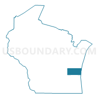
Sheboygan County PUMA, Wisconsin
About
Outline

Summary
| Unique Area Identifier | 194411 |
| Name | Sheboygan County PUMA |
| State | Wisconsin |
| Area (square miles) | 1,271.22 |
| Land Area (square miles) | 511.27 |
| Water Area (square miles) | 759.96 |
| % of Land Area | 40.22 |
| % of Water Area | 59.78 |
| Latitude of the Internal Point | 43.75317540 |
| Longtitude of the Internal Point | -87.66812980 |
Maps

Graphs
Select a template below for downloading or customizing gragh for Sheboygan County PUMA, Wisconsin


Neighbors
Neighoring Public Use Microdata Area (by Name) Neighboring Public Use Microdata Area on the Map
- Fond du Lac & Calumet Counties PUMA, WI
- Manitowoc & Kewaunee Counties PUMA, WI
- Newaygo, Mason, Oceana & Lake Counties PUMA, MI
- Washington & Ozaukee Counties PUMA, WI
Top 10 Neighboring County (by Population) Neighboring County on the Map
- Washington County, WI (131,887)
- Sheboygan County, WI (115,507)
- Fond du Lac County, WI (101,633)
- Ozaukee County, WI (86,395)
- Manitowoc County, WI (81,442)
- Calumet County, WI (48,971)
- Mason County, MI (28,705)
- Oceana County, MI (26,570)
Top 10 Neighboring County Subdivision (by Population) Neighboring County Subdivision on the Map
- Sheboygan city, Sheboygan County, WI (49,288)
- Plymouth city, Sheboygan County, WI (8,445)
- Sheboygan Falls city, Sheboygan County, WI (7,775)
- Sheboygan town, Sheboygan County, WI (7,271)
- Farmington town, Washington County, WI (4,014)
- Wilson town, Sheboygan County, WI (3,330)
- Plymouth town, Sheboygan County, WI (3,195)
- Howards Grove village, Sheboygan County, WI (3,188)
- Lima town, Sheboygan County, WI (2,982)
- Oostburg village, Sheboygan County, WI (2,887)
Top 10 Neighboring Place (by Population) Neighboring Place on the Map
- Sheboygan city, WI (49,288)
- Plymouth city, WI (8,445)
- Sheboygan Falls city, WI (7,775)
- Howards Grove village, WI (3,188)
- Oostburg village, WI (2,887)
- Kohler village, WI (2,120)
- Cedar Grove village, WI (2,113)
- Random Lake village, WI (1,594)
- Elkhart Lake village, WI (967)
- Hingham CDP, WI (886)
Top 10 Neighboring Unified School District (by Population) Neighboring Unified School District on the Map
- Sheboygan Area School District, WI (61,046)
- Plymouth School District, WI (16,964)
- Kewaskum School District, WI (13,693)
- Sheboygan Falls School District, WI (11,485)
- Campbellsport School District, WI (10,613)
- New Holstein School District, WI (9,402)
- Kiel Area School District, WI (8,289)
- Shelby Public Schools, MI (8,188)
- Hart Public School District, MI (7,899)
- Mason County Central Schools, MI (7,804)
Top 10 Neighboring State Legislative District Lower Chamber (by Population) Neighboring State Legislative District Lower Chamber on the Map
- State House District 101, MI (92,671)
- State House District 100, MI (86,569)
- Assembly District 2, WI (61,009)
- Assembly District 59, WI (58,836)
- Assembly District 60, WI (57,434)
- Assembly District 27, WI (56,118)
- Assembly District 25, WI (53,380)
- Assembly District 26, WI (52,721)
Top 10 Neighboring State Legislative District Upper Chamber (by Population) Neighboring State Legislative District Upper Chamber on the Map
- State Senate District 34, MI (275,923)
- State Senate District 1, WI (180,989)
- State Senate District 20, WI (176,381)
- State Senate District 9, WI (162,219)
Top 10 Neighboring 111th Congressional District (by Population) Neighboring 111th Congressional District on the Map
Top 10 Neighboring Census Tract (by Population) Neighboring Census Tract on the Map
- Census Tract 107, Sheboygan County, WI (8,202)
- Census Tract 105.01, Sheboygan County, WI (7,914)
- Census Tract 10, Sheboygan County, WI (7,415)
- Census Tract 419, Fond du Lac County, WI (7,180)
- Census Tract 113, Sheboygan County, WI (7,121)
- Census Tract 3, Sheboygan County, WI (7,111)
- Census Tract 422, Fond du Lac County, WI (6,115)
- Census Tract 106.01, Sheboygan County, WI (5,594)
- Census Tract 8, Sheboygan County, WI (5,397)
- Census Tract 9, Sheboygan County, WI (5,126)
Top 10 Neighboring 5-Digit ZIP Code Tabulation Area (by Population) Neighboring 5-Digit ZIP Code Tabulation Area on the Map
- 53081, WI (43,129)
- 53083, WI (20,362)
- 53073, WI (15,757)
- 53085, WI (11,267)
- 53040, WI (8,064)
- 53010, WI (7,681)
- 53042, WI (6,690)
- 53061, WI (5,196)
- 53070, WI (4,713)
- 53021, WI (4,709)