


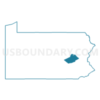
Schuylkill County PUMA, Pennsylvania
About
Outline

Summary
| Unique Area Identifier | 193862 |
| Name | Schuylkill County PUMA |
| State | Pennsylvania |
| Area (square miles) | 782.81 |
| Land Area (square miles) | 778.63 |
| Water Area (square miles) | 4.18 |
| % of Land Area | 99.47 |
| % of Water Area | 0.53 |
| Latitude of the Internal Point | 40.70368990 |
| Longtitude of the Internal Point | -76.21780000 |
Maps

Graphs
Select a template below for downloading or customizing gragh for Schuylkill County PUMA, Pennsylvania


Neighbors
Neighoring Public Use Microdata Area (by Name) Neighboring Public Use Microdata Area on the Map
- Berks County (East) PUMA, PA
- Berks County (Northwest)--Wyomissing Borough PUMA, PA
- Carbon & Lehigh (North) Counties PUMA, PA
- Columbia & Luzerne (West) Counties--Bloomsburg Town & Berwick Borough PUMA, PA
- Dauphin County (Outer)--Hershey PUMA, PA
- Lebanon County PUMA, PA
- Luzerne County (South Central)--Wilkes-Barre & Hazleton Cities PUMA, PA
- Northumberland & Montour Counties PUMA, PA
Top 10 Neighboring County (by Population) Neighboring County on the Map
- Berks County, PA (411,442)
- Lehigh County, PA (349,497)
- Luzerne County, PA (320,918)
- Dauphin County, PA (268,100)
- Schuylkill County, PA (148,289)
- Lebanon County, PA (133,568)
- Northumberland County, PA (94,528)
- Columbia County, PA (67,295)
- Carbon County, PA (65,249)
Top 10 Neighboring County Subdivision (by Population) Neighboring County Subdivision on the Map
- Pottsville city, Schuylkill County, PA (14,324)
- Hazle township, Luzerne County, PA (9,549)
- Tamaqua borough, Schuylkill County, PA (7,107)
- Schuylkill Haven borough, Schuylkill County, PA (5,437)
- Butler township, Schuylkill County, PA (5,224)
- Wayne township, Schuylkill County, PA (5,113)
- Shenandoah borough, Schuylkill County, PA (5,071)
- Bethel township, Lebanon County, PA (5,007)
- West Penn township, Schuylkill County, PA (4,442)
- Minersville borough, Schuylkill County, PA (4,397)
Top 10 Neighboring Place (by Population) Neighboring Place on the Map
- Pottsville city, PA (14,324)
- Tamaqua borough, PA (7,107)
- Schuylkill Haven borough, PA (5,437)
- Shenandoah borough, PA (5,071)
- Minersville borough, PA (4,397)
- Mahanoy City borough, PA (4,162)
- Lansford borough, PA (3,941)
- Frackville borough, PA (3,805)
- Nesquehoning borough, PA (3,349)
- Orwigsburg borough, PA (3,099)
Top 10 Neighboring Unified School District (by Population) Neighboring Unified School District on the Map
- Hazleton Area School District, PA (72,891)
- Shamokin Area School District, PA (20,912)
- Bloomsburg Area School District, PA (20,663)
- Blue Mountain School District, PA (20,471)
- Pottsville Area School District, PA (20,103)
- Kutztown Area School District, PA (19,010)
- Lehighton Area School District, PA (17,885)
- Hamburg Area School District, PA (17,611)
- Northern Lebanon School District, PA (17,419)
- North Schuylkill School District, PA (16,977)
Top 10 Neighboring State Legislative District Lower Chamber (by Population) Neighboring State Legislative District Lower Chamber on the Map
- State House District 187, PA (68,541)
- State House District 102, PA (68,288)
- State House District 129, PA (68,094)
- State House District 122, PA (65,249)
- State House District 116, PA (65,038)
- State House District 124, PA (64,592)
- State House District 104, PA (64,451)
- State House District 125, PA (62,861)
- State House District 109, PA (62,749)
- State House District 108, PA (62,303)
Top 10 Neighboring State Legislative District Upper Chamber (by Population) Neighboring State Legislative District Upper Chamber on the Map
- State Senate District 48, PA (278,934)
- State Senate District 29, PA (260,093)
- State Senate District 27, PA (256,971)
- State Senate District 14, PA (250,131)
Top 10 Neighboring 111th Congressional District (by Population) Neighboring 111th Congressional District on the Map
- Congressional District 15, PA (721,828)
- Congressional District 11, PA (687,860)
- Congressional District 17, PA (681,835)
- Congressional District 10, PA (669,257)
Top 10 Neighboring Census Tract (by Population) Neighboring Census Tract on the Map
- Census Tract 248, Dauphin County, PA (8,207)
- Census Tract 139, Berks County, PA (7,893)
- Census Tract 9, Schuylkill County, PA (7,506)
- Census Tract 205, Carbon County, PA (7,186)
- Census Tract 203, Carbon County, PA (6,383)
- Census Tract 202, Carbon County, PA (6,370)
- Census Tract 101, Berks County, PA (6,029)
- Census Tract 247, Dauphin County, PA (5,998)
- Census Tract 515, Columbia County, PA (5,799)
- Census Tract 4, Schuylkill County, PA (5,611)
Top 10 Neighboring 5-Digit ZIP Code Tabulation Area (by Population) Neighboring 5-Digit ZIP Code Tabulation Area on the Map
- 17815, PA (30,967)
- 18201, PA (27,516)
- 17901, PA (23,990)
- 18235, PA (19,353)
- 18202, PA (12,083)
- 17972, PA (11,627)
- 18252, PA (11,188)
- 19526, PA (11,039)
- 17872, PA (9,943)
- 17963, PA (9,317)