


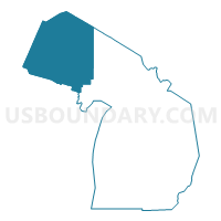
Western Upper Peninsula PUMA, Michigan
About
Outline

Summary
| Unique Area Identifier | 193143 |
| Name | Western Upper Peninsula PUMA |
| State | Michigan |
| Area (square miles) | 19,166.42 |
| Land Area (square miles) | 8,596.49 |
| Water Area (square miles) | 10,569.93 |
| % of Land Area | 44.85 |
| % of Water Area | 55.15 |
| Latitude of the Internal Point | 47.03873300 |
| Longtitude of the Internal Point | -88.48813080 |
Maps

Graphs
Select a template below for downloading or customizing gragh for Western Upper Peninsula PUMA, Michigan


Neighbors
Neighoring Public Use Microdata Area (by Name) Neighboring Public Use Microdata Area on the Map
- Eastern Upper Peninsula PUMA, MI
- Marinette, Oconto, Door & Florence Counties PUMA, WI
- Northwest Wisconsin PUMA, WI
- Oneida, Lincoln, Vilas, Langlade & Forest Counties PUMA, WI
- St. Louis (North), Koochiching, Lake & Cook Counties--Hibbing & Cloquet Cities PUMA, MN
Top 10 Neighboring County (by Population) Neighboring County on the Map
- Marquette County, MI (67,077)
- Marinette County, WI (41,749)
- Delta County, MI (37,069)
- Houghton County, MI (36,628)
- Dickinson County, MI (26,168)
- Menominee County, MI (24,029)
- Vilas County, WI (21,430)
- Gogebic County, MI (16,427)
- Ashland County, WI (16,157)
- Iron County, MI (11,817)
Top 10 Neighboring County Subdivision (by Population) Neighboring County Subdivision on the Map
- Marquette city, Marquette County, MI (21,355)
- Houghton city, Houghton County, MI (7,708)
- Iron Mountain city, Dickinson County, MI (7,624)
- Calumet charter township, Houghton County, MI (6,489)
- Ishpeming city, Marquette County, MI (6,470)
- Forsyth township, Marquette County, MI (6,164)
- Chocolay charter township, Marquette County, MI (5,903)
- Breitung charter township, Dickinson County, MI (5,853)
- Ironwood city, Gogebic County, MI (5,387)
- Kingsford city, Dickinson County, MI (5,133)
Top 10 Neighboring Place (by Population) Neighboring Place on the Map
- Marquette city, MI (21,355)
- Houghton city, MI (7,708)
- Iron Mountain city, MI (7,624)
- Ishpeming city, MI (6,470)
- Ironwood city, MI (5,387)
- Kingsford city, MI (5,133)
- Hancock city, MI (4,634)
- Negaunee city, MI (4,568)
- Iron River city, MI (3,029)
- Norway city, MI (2,845)
Top 10 Neighboring Elementary School District (by Population) Neighboring Elementary School District on the Map
- North Lakeland School District, WI (2,513)
- Stanton Township Public Schools, MI (1,421)
- Autrain-Onota Public Schools, MI (903)
- Powell Township Schools, MI (894)
- Arvon Township School District, MI (450)
- Wells Township School District, MI (222)
- Grant Township School District 2, MI (219)
- Elm River Township School District, MI (177)
Top 10 Neighboring Secondary School District (by Population) Neighboring Secondary School District on the Map
Top 10 Neighboring Unified School District (by Population) Neighboring Unified School District on the Map
- Marquette Area Public Schools, MI (32,158)
- Escanaba Area Public Schools, MI (20,175)
- Northland Pines School District, WI (11,340)
- Breitung Township Schools, MI (11,023)
- Houghton-Portage Township Schools, MI (10,393)
- Gwinn Area Community Schools, MI (9,903)
- Negaunee Public Schools, MI (8,544)
- Calumet Public Schools, MI (8,473)
- Ironwood Area Schools, MI (8,046)
- Iron Mountain Public Schools, MI (7,587)
Top 10 Neighboring State Legislative District Lower Chamber (by Population) Neighboring State Legislative District Lower Chamber on the Map
- State House District 109, MI (90,978)
- State House District 108, MI (87,266)
- State House District 110, MI (83,484)
- Assembly District 34, WI (53,812)
- Assembly District 74, WI (52,623)
- Assembly District 36, WI (50,804)
- State House District 6A, MN (36,396)
Top 10 Neighboring State Legislative District Upper Chamber (by Population) Neighboring State Legislative District Upper Chamber on the Map
- State Senate District 38, MI (261,728)
- State Senate District 25, WI (162,546)
- State Senate District 12, WI (157,332)
- State Senate District 6, MN (76,702)
Top 10 Neighboring 111th Congressional District (by Population) Neighboring 111th Congressional District on the Map
- Congressional District 8, WI (706,840)
- Congressional District 7, WI (689,279)
- Congressional District 8, MN (660,342)
- Congressional District 1, MI (650,222)
Top 10 Neighboring Census Tract (by Population) Neighboring Census Tract on the Map
- Census Tract 8, Houghton County, MI (6,394)
- Census Tract 12, Marquette County, MI (5,565)
- Census Tract 28, Marquette County, MI (5,280)
- Census Tract 9, Houghton County, MI (5,041)
- Census Tract 9503, Dickinson County, MI (4,858)
- Census Tract 2, Baraga County, MI (4,558)
- Census Tract 9504, Dickinson County, MI (4,369)
- Census Tract 9506, Dickinson County, MI (4,342)
- Census Tract 29, Marquette County, MI (4,312)
- Census Tract 1, Baraga County, MI (4,302)
Top 10 Neighboring 5-Digit ZIP Code Tabulation Area (by Population) Neighboring 5-Digit ZIP Code Tabulation Area on the Map
- 49855, MI (33,561)
- 49849, MI (12,242)
- 49801, MI (11,424)
- 49931, MI (9,630)
- 49866, MI (8,034)
- 49938, MI (7,945)
- 49913, MI (7,248)
- 49841, MI (7,016)
- 49930, MI (6,987)
- 49802, MI (6,230)