


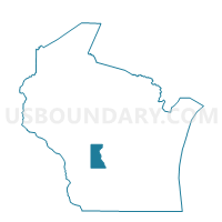
SUMMIT - T 1 Voting District, Juneau County, Wisconsin
About
Outline

Summary
| Unique Area Identifier | 694302 |
| Name | SUMMIT - T 1 Voting District |
| County | Juneau County |
| State | Wisconsin |
| Area (square miles) | 36.93 |
| Land Area (square miles) | 36.91 |
| Water Area (square miles) | 0.01 |
| % of Land Area | 99.96 |
| % of Water Area | 0.04 |
| Latitude of the Internal Point | 43.68899430 |
| Longtitude of the Internal Point | -90.13268840 |
Maps


Graphs
Select a template below for downloading or customizing gragh for SUMMIT - T 1 Voting District, Juneau County, Wisconsin


Neighbors
Neighoring Voting District (by Name) Neighboring Voting District on the Map
- LA VALLE - T 1 Voting District, Sauk County, WI
- LA VALLE - T 2 Voting District, Sauk County, WI
- LEMONWEIR - T 4 Voting District, Juneau County, WI
- LINDINA - T 1 Voting District, Juneau County, WI
- PLYMOUTH - T 2 Voting District, Juneau County, WI
- SEVEN MILE CREEK - T 2 Voting District, Juneau County, WI
- WINFIELD - T 2 Voting District, Sauk County, WI
- WONEWOC - T 1 Voting District, Juneau County, WI
- WONEWOC - T 2 Voting District, Juneau County, WI
- WOODLAND - T 1 Voting District, Sauk County, WI
Top 10 Neighboring County Subdivision (by Population) Neighboring County Subdivision on the Map
- Lemonweir town, Juneau County, WI (1,743)
- La Valle town, Sauk County, WI (1,302)
- Winfield town, Sauk County, WI (856)
- Woodland town, Sauk County, WI (790)
- Lindina town, Juneau County, WI (718)
- Wonewoc town, Juneau County, WI (687)
- Summit town, Juneau County, WI (646)
- Plymouth town, Juneau County, WI (597)
- Seven Mile Creek town, Juneau County, WI (358)
Top 10 Neighboring Unified School District (by Population) Neighboring Unified School District on the Map
- Reedsburg School District, WI (16,838)
- Mauston School District, WI (10,238)
- Royall School District, WI (5,511)
- Wonewoc-Union Center School District, WI (2,982)
Top 10 Neighboring State Legislative District Lower Chamber (by Population) Neighboring State Legislative District Lower Chamber on the Map
Top 10 Neighboring State Legislative District Upper Chamber (by Population) Neighboring State Legislative District Upper Chamber on the Map
Top 10 Neighboring 111th Congressional District (by Population) Neighboring 111th Congressional District on the Map
Top 10 Neighboring Census Tract (by Population) Neighboring Census Tract on the Map
- Census Tract 9, Sauk County, WI (4,792)
- Census Tract 1007, Juneau County, WI (4,037)
- Census Tract 1006, Juneau County, WI (3,383)