


Butterfield Voting District, Yakima County, Washington
About
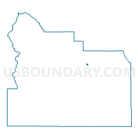
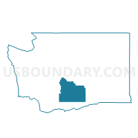
Outline

Summary
| Unique Area Identifier | 690219 |
| Name | Butterfield Voting District |
| County | Yakima County |
| State | Washington |
| Area (square miles) | 0.50 |
| Land Area (square miles) | 0.50 |
| Water Area (square miles) | 0.00 |
| % of Land Area | 100.00 |
| % of Water Area | 0.00 |
| Latitude of the Internal Point | 46.61221920 |
| Longtitude of the Internal Point | -120.45613890 |
Maps

Graphs
Select a template below for downloading or customizing gragh for Butterfield Voting District, Yakima County, Washington


Neighbors
Neighoring Voting District (by Name) Neighboring Voting District on the Map
- Country Club Voting District, Yakima County, WA
- Rest Haven Voting District, Yakima County, WA
- Slavin Voting District, Yakima County, WA
- Terrace Heights Voting District, Yakima County, WA
- Yakima Ridge Voting District, Yakima County, WA