


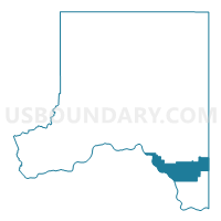
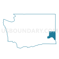
Colton Voting District, Whitman County, Washington
About
Outline

Summary
| Unique Area Identifier | 690121 |
| Name | Colton Voting District |
| County | Whitman County |
| State | Washington |
| Area (square miles) | 75.55 |
| Land Area (square miles) | 72.77 |
| Water Area (square miles) | 2.77 |
| % of Land Area | 96.33 |
| % of Water Area | 3.67 |
| Latitude of the Internal Point | 46.60296430 |
| Longtitude of the Internal Point | -117.22055910 |
Maps

Graphs
Select a template below for downloading or customizing gragh for Colton Voting District, Whitman County, Washington


Neighbors
Neighoring Voting District (by Name) Neighboring Voting District on the Map
- Voting District 057007, Latah County, ID
- Voting District 057021, Latah County, ID
- Mayview Voting District, Garfield County, WA
- Pleasant Voting District, Garfield County, WA
- South Pullman Voting District, Whitman County, WA
- Uniontown Voting District, Whitman County, WA
Top 10 Neighboring County Subdivision (by Population) Neighboring County Subdivision on the Map
- Pullman CCD, Whitman County, WA (31,900)
- Moscow CCD, Latah County, ID (26,914)
- Genesee CCD, Latah County, ID (1,450)
- Uniontown CCD, Whitman County, WA (1,194)
- Snake River CCD, Garfield County, WA (391)
Top 10 Neighboring Place (by Population) Neighboring Place on the Map
Top 10 Neighboring Unified School District (by Population) Neighboring Unified School District on the Map
- Pullman School District, WA (31,922)
- Moscow School District 281, ID (27,525)
- Pomeroy School District, WA (2,191)
- Genesee Joint School District 282, ID (1,716)
- Colton School District, WA (1,106)
Top 10 Neighboring State Legislative District Lower Chamber (by Population) Neighboring State Legislative District Lower Chamber on the Map
Top 10 Neighboring State Legislative District Upper Chamber (by Population) Neighboring State Legislative District Upper Chamber on the Map
Top 10 Neighboring 111th Congressional District (by Population) Neighboring 111th Congressional District on the Map
Top 10 Neighboring Census Tract (by Population) Neighboring Census Tract on the Map
- Census Tract 54, Latah County, ID (6,435)
- Census Tract 3, Whitman County, WA (4,504)
- Census Tract 4, Whitman County, WA (3,738)
- Census Tract 57, Latah County, ID (2,958)
- Census Tract 9703, Garfield County, WA (2,266)
- Census Tract 10, Whitman County, WA (2,115)
Top 10 Neighboring 5-Digit ZIP Code Tabulation Area (by Population) Neighboring 5-Digit ZIP Code Tabulation Area on the Map
- 99163, WA (31,404)
- 83843, ID (25,866)
- 99347, WA (2,293)
- 83832, ID (1,524)
- 99113, WA (761)
- 99179, WA (437)