


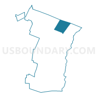
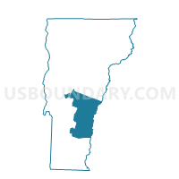
Sharon Voting District, Windsor County, Vermont
About
Outline

Summary
| Unique Area Identifier | 680954 |
| Name | Sharon Voting District |
| County | Windsor County |
| State | Vermont |
| Area (square miles) | 40.16 |
| Land Area (square miles) | 39.66 |
| Water Area (square miles) | 0.50 |
| % of Land Area | 98.75 |
| % of Water Area | 1.25 |
| Latitude of the Internal Point | 43.78756970 |
| Longtitude of the Internal Point | -72.43519190 |
Maps

Graphs
Select a template below for downloading or customizing gragh for Sharon Voting District, Windsor County, Vermont


Neighbors
Neighoring Voting District (by Name) Neighboring Voting District on the Map
- Hartford District 1, Windsor County, VT
- Norwich Voting District, Windsor County, VT
- Pomfret Voting District, Windsor County, VT
- Royalton Voting District, Windsor County, VT
- Strafford Voting District, Orange County, VT
- Thetford Voting District, Orange County, VT
- Tunbridge Voting District, Orange County, VT
Top 10 Neighboring County Subdivision (by Population) Neighboring County Subdivision on the Map
- Hartford town, Windsor County, VT (9,952)
- Norwich town, Windsor County, VT (3,414)
- Royalton town, Windsor County, VT (2,773)
- Thetford town, Orange County, VT (2,588)
- Sharon town, Windsor County, VT (1,502)
- Tunbridge town, Orange County, VT (1,284)
- Strafford town, Orange County, VT (1,098)
- Pomfret town, Windsor County, VT (904)
Top 10 Neighboring Elementary School District (by Population) Neighboring Elementary School District on the Map
- Norwich School District, VT (3,414)
- Thetford School District, VT (2,588)
- Sharon School District, VT (1,502)
- Tunbridge School District, VT (1,284)
- Pomfret School District, VT (904)
Top 10 Neighboring Secondary School District (by Population) Neighboring Secondary School District on the Map
Top 10 Neighboring Unified School District (by Population) Neighboring Unified School District on the Map
- Hartford School District, VT (9,952)
- Royalton School District, VT (2,773)
- Strafford School District, VT (1,098)
Top 10 Neighboring State Legislative District Lower Chamber (by Population) Neighboring State Legislative District Lower Chamber on the Map
- Windsor-Orange-2 State House District, VT (8,602)
- Windsor-Orange-1 State House District, VT (4,057)
- Windsor-6-1 State House District, VT (3,811)
Top 10 Neighboring State Legislative District Upper Chamber (by Population) Neighboring State Legislative District Upper Chamber on the Map
Top 10 Neighboring 111th Congressional District (by Population) Neighboring 111th Congressional District on the Map
Top 10 Neighboring Census Tract (by Population) Neighboring Census Tract on the Map
- Census Tract 9595, Orange County, VT (4,350)
- Census Tract 9654, Windsor County, VT (4,089)
- Census Tract 9650, Windsor County, VT (3,414)
- Census Tract 9655.01, Windsor County, VT (2,998)
- Census Tract 9655.02, Windsor County, VT (2,811)
- Census Tract 9651, Windsor County, VT (2,773)
- Census Tract 9596, Orange County, VT (2,588)
Top 10 Neighboring 5-Digit ZIP Code Tabulation Area (by Population) Neighboring 5-Digit ZIP Code Tabulation Area on the Map
- 05001, VT (9,123)
- 05055, VT (3,363)
- 05068, VT (3,125)
- 05077, VT (1,215)
- 05075, VT (1,113)
- 05065, VT (1,064)
- 05072, VT (526)
- 05070, VT (484)
- 05053, VT (332)
- 05084, VT (140)