


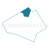
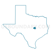
Voting District 0311, Bell County, Texas
About
Outline

Summary
| Unique Area Identifier | 670292 |
| Name | Voting District 0311 |
| County | Bell County |
| State | Texas |
| Area (square miles) | 69.06 |
| Land Area (square miles) | 61.92 |
| Water Area (square miles) | 7.14 |
| % of Land Area | 89.66 |
| % of Water Area | 10.34 |
| Latitude of the Internal Point | 31.25578830 |
| Longtitude of the Internal Point | -97.45829940 |
Maps

Graphs
Select a template below for downloading or customizing gragh for Voting District 0311, Bell County, Texas


Neighbors
Neighoring Voting District (by Name) Neighboring Voting District on the Map
- Voting District 0077, McLennan County, TX
- Voting District 0104, Bell County, TX
- Voting District 0111, Bell County, TX
- Voting District 0112, Bell County, TX
- Voting District 0301, Bell County, TX
- Voting District 0312, Coryell County, TX
- Voting District 0314, Coryell County, TX
- Voting District 0315, Coryell County, TX
- Voting District 0315, Bell County, TX
- Voting District 0317, Bell County, TX
Top 10 Neighboring County Subdivision (by Population) Neighboring County Subdivision on the Map
- Temple CCD, Bell County, TX (69,183)
- Fort Hood CCD, Bell County, TX (15,596)
- Fort Hood CCD, Coryell County, TX (14,852)
- Northwest Bell CCD, Bell County, TX (12,591)
- Moody-Lorena CCD, McLennan County, TX (12,584)
- East Bell CCD, Bell County, TX (6,219)
- Oglesby CCD, Coryell County, TX (1,894)
- Flat CCD, Coryell County, TX (982)
Top 10 Neighboring Place (by Population) Neighboring Place on the Map
Top 10 Neighboring Unified School District (by Population) Neighboring Unified School District on the Map
- Belton Independent School District, TX (45,179)
- Gatesville Independent School District, TX (23,029)
- Troy Independent School District, TX (5,977)
- Moody Independent School District, TX (4,408)
Top 10 Neighboring State Legislative District Lower Chamber (by Population) Neighboring State Legislative District Lower Chamber on the Map
- State House District 55, TX (176,215)
- State House District 56, TX (155,303)
- State House District 59, TX (149,195)
Top 10 Neighboring State Legislative District Upper Chamber (by Population) Neighboring State Legislative District Upper Chamber on the Map
Top 10 Neighboring 111th Congressional District (by Population) Neighboring 111th Congressional District on the Map
Top 10 Neighboring Census Tract (by Population) Neighboring Census Tract on the Map
- Census Tract 203, Bell County, TX (7,838)
- Census Tract 202.02, Bell County, TX (6,574)
- Census Tract 201, Bell County, TX (6,219)
- Census Tract 38.02, McLennan County, TX (6,002)
- Census Tract 101.01, Coryell County, TX (3,606)
- Census Tract 9800, Coryell County, TX (26)
- Census Tract 9800.03, Bell County, TX (0)