


WORTH TWP Voting District, Mercer County, Pennsylvania
About
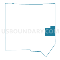
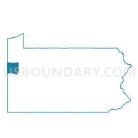
Outline

Summary
| Unique Area Identifier | 661090 |
| Name | WORTH TWP Voting District |
| County | Mercer County |
| State | Pennsylvania |
| Area (square miles) | 24.85 |
| Land Area (square miles) | 24.68 |
| Water Area (square miles) | 0.17 |
| % of Land Area | 99.30 |
| % of Water Area | 0.70 |
| Latitude of the Internal Point | 41.27209500 |
| Longtitude of the Internal Point | -80.05120270 |
Maps

Graphs
Select a template below for downloading or customizing gragh for WORTH TWP Voting District, Mercer County, Pennsylvania


Neighbors
Neighoring Voting District (by Name) Neighboring Voting District on the Map
- IRWIN TWP Voting District, Venango County, PA
- JACKSON TWP Voting District, Mercer County, PA
- MINERAL TWP Voting District, Venango County, PA
- SANDY LAKE TWP Voting District, Mercer County, PA
- WOLF CREEK TWP Voting District, Mercer County, PA
Top 10 Neighboring County Subdivision (by Population) Neighboring County Subdivision on the Map
- Irwin township, Venango County, PA (1,391)
- Jackson township, Mercer County, PA (1,273)
- Sandy Lake township, Mercer County, PA (1,226)
- Worth township, Mercer County, PA (899)
- Wolf Creek township, Mercer County, PA (832)
- Mineral township, Venango County, PA (538)
Top 10 Neighboring Unified School District (by Population) Neighboring Unified School District on the Map
- Grove City Area School District, PA (17,699)
- Franklin Area School District, PA (16,283)
- Lakeview School District, PA (8,610)
Top 10 Neighboring State Legislative District Lower Chamber (by Population) Neighboring State Legislative District Lower Chamber on the Map
- State House District 8, PA (62,230)
- State House District 64, PA (59,331)
- State House District 17, PA (58,819)
Top 10 Neighboring State Legislative District Upper Chamber (by Population) Neighboring State Legislative District Upper Chamber on the Map
Top 10 Neighboring 111th Congressional District (by Population) Neighboring 111th Congressional District on the Map
Top 10 Neighboring Census Tract (by Population) Neighboring Census Tract on the Map
- Census Tract 325.01, Mercer County, PA (6,214)
- Census Tract 328, Mercer County, PA (5,948)
- Census Tract 2014, Venango County, PA (3,908)
- Census Tract 325.02, Mercer County, PA (2,396)