


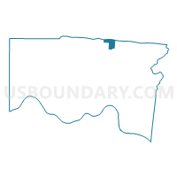
Voting District SPRINGDALE E, Hamilton County, Ohio
About
Outline

Summary
| Unique Area Identifier | 646960 |
| Name | Voting District SPRINGDALE E |
| County | Hamilton County |
| State | Ohio |
| Area (square miles) | 2.17 |
| Land Area (square miles) | 2.17 |
| Water Area (square miles) | 0.00 |
| % of Land Area | 100.00 |
| % of Water Area | 0.00 |
| Latitude of the Internal Point | 39.29186270 |
| Longtitude of the Internal Point | -84.46171940 |
Maps

Graphs
Select a template below for downloading or customizing gragh for Voting District SPRINGDALE E, Hamilton County, Ohio


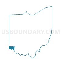
Neighbors
Neighoring Voting District (by Name) Neighboring Voting District on the Map
- FAIRFIELD CITY FAIR2WD1 Voting District, Butler County, OH
- FAIRFIELD CITY FAIR8WD1 Voting District, Butler County, OH
- Voting District GLENDALE A, Hamilton County, OH
- Voting District GLENDALE B, Hamilton County, OH
- Voting District SHARONVILLE 1-A, Hamilton County, OH
- Voting District SHARONVILLE 1-B, Hamilton County, OH
- Voting District SPRINGDALE D, Hamilton County, OH
- Voting District SPRINGDALE F, Hamilton County, OH
- Voting District SPRINGDALE G, Hamilton County, OH
- Voting District SPRINGDALE H, Hamilton County, OH
- Voting District SPRINGDALE I, Hamilton County, OH
- WEST CHESTER TWP WC30 Voting District, Butler County, OH
Top 10 Neighboring County Subdivision (by Population) Neighboring County Subdivision on the Map
- West Chester township, Butler County, OH (60,958)
- Fairfield city, Butler County, OH (42,510)
- Springdale city, Hamilton County, OH (11,223)
- Sharonville city, Hamilton County, OH (11,197)
- Glendale village, Hamilton County, OH (2,155)
Top 10 Neighboring Place (by Population) Neighboring Place on the Map
- Fairfield city, OH (42,510)
- Sharonville city, OH (13,560)
- Springdale city, OH (11,223)
- Glendale village, OH (2,155)
Top 10 Neighboring Unified School District (by Population) Neighboring Unified School District on the Map
- Lakota Local School District, OH (93,820)
- Fairfield City School District, OH (64,878)
- Princeton City School District, OH (42,620)
Top 10 Neighboring State Legislative District Lower Chamber (by Population) Neighboring State Legislative District Lower Chamber on the Map
- State House District 55, OH (135,473)
- State House District 54, OH (114,483)
- State House District 28, OH (109,005)
Top 10 Neighboring State Legislative District Upper Chamber (by Population) Neighboring State Legislative District Upper Chamber on the Map
Top 10 Neighboring 111th Congressional District (by Population) Neighboring 111th Congressional District on the Map
- Congressional District 2, OH (673,873)
- Congressional District 8, OH (663,644)
- Congressional District 1, OH (598,699)
Top 10 Neighboring Census Tract (by Population) Neighboring Census Tract on the Map
- Census Tract 223.01, Hamilton County, OH (6,101)
- Census Tract 111.23, Butler County, OH (5,075)
- Census Tract 215.01, Hamilton County, OH (4,834)
- Census Tract 109.09, Butler County, OH (4,716)
- Census Tract 230.01, Hamilton County, OH (4,372)
- Census Tract 224, Hamilton County, OH (2,155)