


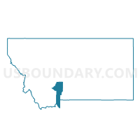
Precinct 16, Gallatin County, Montana
About
Outline

Summary
| Unique Area Identifier | 612016 |
| Name | Precinct 16 |
| County | Gallatin County |
| State | Montana |
| Area (square miles) | 275.46 |
| Land Area (square miles) | 275.28 |
| Water Area (square miles) | 0.18 |
| % of Land Area | 99.94 |
| % of Water Area | 0.06 |
| Latitude of the Internal Point | 45.99152820 |
| Longtitude of the Internal Point | -110.87377710 |
Maps


Graphs
Select a template below for downloading or customizing gragh for Precinct 16, Gallatin County, Montana


Neighbors
Neighoring Voting District (by Name) Neighboring Voting District on the Map
- 7-C Wilsall, Park County, MT
- 7-D Clyde Park, Park County, MT
- Precinct 15, Gallatin County, MT
- Precinct 17, Gallatin County, MT
- Precinct 20, Gallatin County, MT
- Precinct 5, Meagher County, MT
Top 10 Neighboring County Subdivision (by Population) Neighboring County Subdivision on the Map
- Bozeman CCD, Gallatin County, MT (49,560)
- Belgrade CCD, Gallatin County, MT (23,200)
- Shields Valley CCD, Park County, MT (1,785)
- Martinsdale-Ringling CCD, Meagher County, MT (378)
Top 10 Neighboring Place (by Population) Neighboring Place on the Map
Top 10 Neighboring Elementary School District (by Population) Neighboring Elementary School District on the Map
- Bozeman Elementary School District, MT (51,460)
- Belgrade Elementary School District, MT (19,906)
- Livingston Elementary School District, MT (10,406)
- White Sulphur Springs Elementary School District, MT (1,766)
- Shields Valley Elementary School District, MT (1,628)
- Springhill Elementary School District, MT (115)
- Pass Creek Elementary School District, MT (95)
- Ringling Elementary School District, MT (66)
Top 10 Neighboring Secondary School District (by Population) Neighboring Secondary School District on the Map
- Bozeman High School District, MT (59,653)
- Belgrade High School District, MT (20,094)
- Park High School District, MT (12,795)
- Manhattan High School District, MT (4,564)
- White Sulphur Springs High School District, MT (1,891)
- Shields Valley High School District, MT (1,628)
Top 10 Neighboring State Legislative District Lower Chamber (by Population) Neighboring State Legislative District Lower Chamber on the Map
- State House District 63, MT (10,738)
- State House District 68, MT (10,656)
- State House District 61, MT (9,919)
- State House District 83, MT (9,653)
Top 10 Neighboring State Legislative District Upper Chamber (by Population) Neighboring State Legislative District Upper Chamber on the Map
- State Senate District 34, MT (25,583)
- State Senate District 32, MT (23,354)
- State Senate District 42, MT (20,506)
- State Senate District 31, MT (18,534)
Top 10 Neighboring 111th Congressional District (by Population) Neighboring 111th Congressional District on the Map
Top 10 Neighboring Census Tract (by Population) Neighboring Census Tract on the Map
- Census Tract 1.02, Gallatin County, MT (1,980)
- Census Tract 5.01, Gallatin County, MT (1,940)
- Census Tract 1, Meagher County, MT (1,891)
- Census Tract 1, Park County, MT (1,785)
Top 10 Neighboring 5-Digit ZIP Code Tabulation Area (by Population) Neighboring 5-Digit ZIP Code Tabulation Area on the Map
- 59715, MT (31,567)
- 59714, MT (18,182)
- 59645, MT (1,635)
- 59086, MT (727)
- 59018, MT (602)
- 59642, MT (62)