


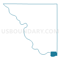
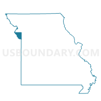
Riverside 1 Voting District, Platte County, Missouri
About
Outline

Summary
| Unique Area Identifier | 609431 |
| Name | Riverside 1 Voting District |
| County | Platte County |
| State | Missouri |
| Area (square miles) | 6.67 |
| Land Area (square miles) | 6.39 |
| Water Area (square miles) | 0.28 |
| % of Land Area | 95.86 |
| % of Water Area | 4.14 |
| Latitude of the Internal Point | 39.17219650 |
| Longtitude of the Internal Point | -94.63253390 |
Maps

Graphs
Select a template below for downloading or customizing gragh for Riverside 1 Voting District, Platte County, Missouri


Neighbors
Neighoring Voting District (by Name) Neighboring Voting District on the Map
- Kansas City Ward 1 Precinct 01, Wyandotte County, KS
- Kansas City Ward 13 Precinct 01, Wyandotte County, KS
- Kansas City Ward 2 Precinct 01, Wyandotte County, KS
- KC 21-2 Voting District, Clay County, MO
- Line Creek 38 Voting District, Platte County, MO
- Northmoor 3 Voting District, Platte County, MO
- Parkville 5 Voting District, Platte County, MO
- South-East 37 Voting District, Platte County, MO
Top 10 Neighboring County Subdivision (by Population) Neighboring County Subdivision on the Map
- Kansas City city, Wyandotte County, KS (145,786)
- Gallatin township, Clay County, MO (68,393)
- Fox township, Platte County, MO (11,791)
- Sioux township, Platte County, MO (11,497)
- Pawnee township, Platte County, MO (8,922)
- Pettis township, Platte County, MO (4,558)
Top 10 Neighboring Place (by Population) Neighboring Place on the Map
- Kansas City city, MO (459,787)
- Kansas City city, KS (145,786)
- Parkville city, MO (5,554)
- Riverside city, MO (2,937)
- Northmoor city, MO (325)
Top 10 Neighboring Unified School District (by Population) Neighboring Unified School District on the Map
- North Kansas City School District, MO (123,348)
- Kansas City Unified School District 500, KS (115,219)
- Park Hill School District, MO (62,261)
Top 10 Neighboring State Legislative District Lower Chamber (by Population) Neighboring State Legislative District Lower Chamber on the Map
- State House District 32, MO (43,330)
- State House District 31, MO (34,655)
- State House District 35, KS (20,403)
Top 10 Neighboring State Legislative District Upper Chamber (by Population) Neighboring State Legislative District Upper Chamber on the Map
- State Senate District 17, MO (199,316)
- State Senate District 34, MO (178,523)
- State Senate District 4, KS (62,358)
Top 10 Neighboring 111th Congressional District (by Population) Neighboring 111th Congressional District on the Map
Top 10 Neighboring Census Tract (by Population) Neighboring Census Tract on the Map
- Census Tract 300.01, Platte County, MO (7,735)
- Census Tract 301.03, Platte County, MO (5,365)
- Census Tract 221, Clay County, MO (4,283)
- Census Tract 202.02, Clay County, MO (3,685)
- Census Tract 301.01, Platte County, MO (3,194)
- Census Tract 300.02, Platte County, MO (2,828)
- Census Tract 446.03, Wyandotte County, KS (0)
- Census Tract 400.01, Wyandotte County, KS (0)
Top 10 Neighboring 5-Digit ZIP Code Tabulation Area (by Population) Neighboring 5-Digit ZIP Code Tabulation Area on the Map
- 64118, MO (40,191)
- 64152, MO (26,024)
- 66104, KS (25,401)
- 64151, MO (24,134)
- 64116, MO (15,318)
- 64150, MO (3,048)
- 66115, KS (0)