


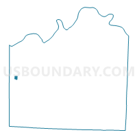
KC WD8 PCT809, Jackson County, Missouri
About
Outline

Summary
| Unique Area Identifier | 608613 |
| Name | KC WD8 PCT809 |
| County | Jackson County |
| State | Missouri |
| Area (square miles) | 0.35 |
| Land Area (square miles) | 0.35 |
| Water Area (square miles) | 0.00 |
| % of Land Area | 100.00 |
| % of Water Area | 0.00 |
| Latitude of the Internal Point | 39.00660930 |
| Longtitude of the Internal Point | -94.57940770 |
Maps


Graphs
Select a template below for downloading or customizing gragh for KC WD8 PCT809, Jackson County, Missouri


Neighbors
Neighoring Voting District (by Name) Neighboring Voting District on the Map
- KC WD17 PCT1814, Jackson County, MO
- KC WD18 PCT1801, Jackson County, MO
- KC WD8 PCT803, Jackson County, MO
- KC WD8 PCT808, Jackson County, MO
- KC WD8 PCT810, Jackson County, MO
- KC WD8 PCT811, Jackson County, MO
- KC WD8 PCT813, Jackson County, MO
Top 10 Neighboring County Subdivision (by Population) Neighboring County Subdivision on the Map
Top 10 Neighboring Place (by Population) Neighboring Place on the Map
Top 10 Neighboring Unified School District (by Population) Neighboring Unified School District on the Map
Top 10 Neighboring State Legislative District Lower Chamber (by Population) Neighboring State Legislative District Lower Chamber on the Map
- State House District 44, MO (32,845)
- State House District 39, MO (32,519)
- State House District 43, MO (29,494)