


Bowstring Twp. Voting District, Itasca County, Minnesota
About
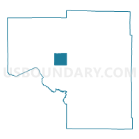
Outline

Summary
| Unique Area Identifier | 602610 |
| Name | Bowstring Twp. Voting District |
| County | Itasca County |
| State | Minnesota |
| Area (square miles) | 35.86 |
| Land Area (square miles) | 26.54 |
| Water Area (square miles) | 9.32 |
| % of Land Area | 74.00 |
| % of Water Area | 26.00 |
| Latitude of the Internal Point | 47.54302400 |
| Longtitude of the Internal Point | -93.83555640 |
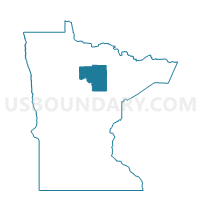
Maps

Graphs
Select a template below for downloading or customizing gragh for Bowstring Twp. Voting District, Itasca County, Minnesota


Neighbors
Neighoring Voting District (by Name) Neighboring Voting District on the Map
- Grave Lake Prec., Itasca County, MN
- Inger Prec., Itasca County, MN
- Lake Jessie Twp. Voting District, Itasca County, MN
- Marcell Twp. Voting District, Itasca County, MN
- Oteneagen Twp. Voting District, Itasca County, MN
- Sand Lake Twp. Voting District, Itasca County, MN
Top 10 Neighboring County Subdivision (by Population) Neighboring County Subdivision on the Map
- Deer Lake UT, Itasca County, MN (3,495)
- Bowstring Lake UT, Itasca County, MN (1,166)
- Marcell township, Itasca County, MN (467)
- Oteneagen township, Itasca County, MN (310)
- Lake Jessie township, Itasca County, MN (303)
- Bowstring township, Itasca County, MN (230)
- Sand Lake township, Itasca County, MN (146)
Top 10 Neighboring Unified School District (by Population) Neighboring Unified School District on the Map
Top 10 Neighboring State Legislative District Lower Chamber (by Population) Neighboring State Legislative District Lower Chamber on the Map
- State House District 4A, MN (39,479)
- State House District 3B, MN (38,405)
- State House District 3A, MN (35,316)
Top 10 Neighboring State Legislative District Upper Chamber (by Population) Neighboring State Legislative District Upper Chamber on the Map
Top 10 Neighboring 111th Congressional District (by Population) Neighboring 111th Congressional District on the Map
Top 10 Neighboring Census Tract (by Population) Neighboring Census Tract on the Map
- Census Tract 4803, Itasca County, MN (4,339)
- Census Tract 4804, Itasca County, MN (3,594)
- Census Tract 4801, Itasca County, MN (2,649)
- Census Tract 9400, Itasca County, MN (2,641)