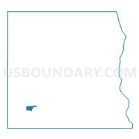
Spring Grove Voting District, Houston County, Minnesota
About
Outline

Summary
| Unique Area Identifier | 602524 |
| Name | Spring Grove Voting District |
| County | Houston County |
| State | Minnesota |
| Area (square miles) | 0.95 |
| Land Area (square miles) | 0.95 |
| Water Area (square miles) | 0.00 |
| % of Land Area | 99.97 |
| % of Water Area | 0.03 |
| Latitude of the Internal Point | 43.56075440 |
| Longtitude of the Internal Point | -91.63696680 |
Maps

Graphs
Select a template below for downloading or customizing gragh for Spring Grove Voting District, Houston County, Minnesota