


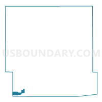
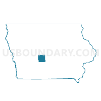
DEXTER Voting District, Dallas County, Iowa
About
Outline

Summary
| Unique Area Identifier | 581906 |
| Name | DEXTER Voting District |
| County | Dallas County |
| State | Iowa |
| Area (square miles) | 2.35 |
| Land Area (square miles) | 2.35 |
| Water Area (square miles) | 0.00 |
| % of Land Area | 100.00 |
| % of Water Area | 0.00 |
| Latitude of the Internal Point | 41.51790660 |
| Longtitude of the Internal Point | -94.21101190 |
Maps

Graphs
Select a template below for downloading or customizing gragh for DEXTER Voting District, Dallas County, Iowa


Neighbors
Neighoring Voting District (by Name) Neighboring Voting District on the Map
- PENN TWP Voting District, Guthrie County, IA
- UNION TWP W/O DEXTER Voting District, Dallas County, IA
Top 10 Neighboring County Subdivision (by Population) Neighboring County Subdivision on the Map
Top 10 Neighboring Place (by Population) Neighboring Place on the Map
Top 10 Neighboring Unified School District (by Population) Neighboring Unified School District on the Map
- West Central Valley Community School District, IA (5,805)
- Earlham Community School District, IA (2,924)