


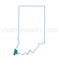
LYNN EAST, Posey County, Indiana
About
Outline

Summary
| Unique Area Identifier | 580207 |
| Name | LYNN EAST |
| County | Posey County |
| State | Indiana |
| Area (square miles) | 25.12 |
| Land Area (square miles) | 25.09 |
| Water Area (square miles) | 0.03 |
| % of Land Area | 99.89 |
| % of Water Area | 0.11 |
| Latitude of the Internal Point | 38.04338830 |
| Longtitude of the Internal Point | -87.89126640 |
Maps


Graphs
Select a template below for downloading or customizing gragh for LYNN EAST, Posey County, Indiana


Neighbors
Neighoring Voting District (by Name) Neighboring Voting District on the Map
- BLACK 01, Posey County, IN
- BLACK 02, Posey County, IN
- CENTER SOUTH, Posey County, IN
- HARMONY 03, Posey County, IN
- LYNN WEST, Posey County, IN
- MARRS NORTH, Posey County, IN
- ROBINSON 01, Posey County, IN
Top 10 Neighboring County Subdivision (by Population) Neighboring County Subdivision on the Map
- Black township, Posey County, IN (9,450)
- Marrs township, Posey County, IN (5,177)
- Robinson township, Posey County, IN (3,942)
- Center township, Posey County, IN (1,433)
- Harmony township, Posey County, IN (1,338)
- Lynn township, Posey County, IN (895)
Top 10 Neighboring Unified School District (by Population) Neighboring Unified School District on the Map
- Mount Vernon Metropolitan School District, IN (15,903)
- North Posey County Schools Metropolitan School District, IN (8,669)
- New Harmony Town and Township Consolidated Schools, IN (1,338)