


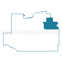
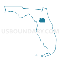
1030-Voting District, Marion County, Florida
About
Outline

Summary
| Unique Area Identifier | 555234 |
| Name | 1030-Voting District |
| County | Marion County |
| State | Florida |
| Area (square miles) | 117.84 |
| Land Area (square miles) | 106.87 |
| Water Area (square miles) | 10.97 |
| % of Land Area | 90.69 |
| % of Water Area | 9.31 |
| Latitude of the Internal Point | 29.33637440 |
| Longtitude of the Internal Point | -81.77808180 |
Maps

Graphs
Select a template below for downloading or customizing gragh for 1030-Voting District, Marion County, Florida


Neighbors
Neighoring Voting District (by Name) Neighboring Voting District on the Map
- 1-Voting District (Astor), Lake County, FL
- 1000-Voting District, Marion County, FL
- 101-Voting District, Volusia County, FL
- 1040-Voting District, Marion County, FL
- 1060-Voting District, Marion County, FL
- 1070-Voting District, Marion County, FL
- 3-Voting District, Putnam County, FL
- 50-Voting District, Putnam County, FL
- 55-Voting District, Putnam County, FL
Top 10 Neighboring County Subdivision (by Population) Neighboring County Subdivision on the Map
- Umatilla CCD, Lake County, FL (25,544)
- East Marion CCD, Marion County, FL (19,408)
- Fort McCoy-Anthony CCD, Marion County, FL (19,230)
- Crescent City CCD, Putnam County, FL (16,384)
- Pierson-Seville CCD, Volusia County, FL (8,231)
Top 10 Neighboring Unified School District (by Population) Neighboring Unified School District on the Map
- Volusia County School District, FL (494,593)
- Marion County School District, FL (331,298)
- Lake County School District, FL (297,052)
- Putnam County School District, FL (74,364)
Top 10 Neighboring State Legislative District Lower Chamber (by Population) Neighboring State Legislative District Lower Chamber on the Map
Top 10 Neighboring State Legislative District Upper Chamber (by Population) Neighboring State Legislative District Upper Chamber on the Map
- State Senate District 20, FL (576,207)
- State Senate District 14, FL (457,489)
- State Senate District 7, FL (432,554)
Top 10 Neighboring 111th Congressional District (by Population) Neighboring 111th Congressional District on the Map
Top 10 Neighboring Census Tract (by Population) Neighboring Census Tract on the Map
- Census Tract 4.02, Marion County, FL (5,363)
- Census Tract 9513, Putnam County, FL (3,749)
- Census Tract 6.01, Marion County, FL (3,723)
- Census Tract 301.02, Lake County, FL (3,512)
- Census Tract 901.02, Volusia County, FL (3,473)
- Census Tract 4.01, Marion County, FL (2,350)
- Census Tract 5.01, Marion County, FL (2,027)
- Census Tract 5.02, Marion County, FL (1,419)