


Fayette County PUMA, Pennsylvania
About
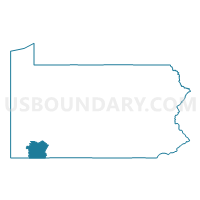
Outline

Summary
| Unique Area Identifier | 193896 |
| Name | Fayette County PUMA |
| State | Pennsylvania |
| Area (square miles) | 798.31 |
| Land Area (square miles) | 790.34 |
| Water Area (square miles) | 7.97 |
| % of Land Area | 99.00 |
| % of Water Area | 1.00 |
| Latitude of the Internal Point | 39.91411540 |
| Longtitude of the Internal Point | -79.64458560 |
Maps

Graphs
Select a template below for downloading or customizing gragh for Fayette County PUMA, Pennsylvania


Neighbors
Neighoring Public Use Microdata Area (by Name) Neighboring Public Use Microdata Area on the Map
- Allegany & Garrett Counties--Cumberland City PUMA, MD
- Monongalia & Preston Counties--Morgantown City PUMA, WV
- Somerset, Bedford & Fulton Counties PUMA, PA
- Washington (South) & Greene Counties PUMA, PA
- Westmoreland County (East) PUMA, PA
- Westmoreland County (Southwest)--Greensburg City PUMA, PA
Top 10 Neighboring County (by Population) Neighboring County on the Map
- Westmoreland County, PA (365,169)
- Washington County, PA (207,820)
- Fayette County, PA (136,606)
- Monongalia County, WV (96,189)
- Somerset County, PA (77,742)
- Greene County, PA (38,686)
- Preston County, WV (33,520)
- Garrett County, MD (30,097)
Top 10 Neighboring County Subdivision (by Population) Neighboring County Subdivision on the Map
- Eastern district, Monongalia County, WV (39,767)
- Western district, Monongalia County, WV (27,045)
- North Union township, Fayette County, PA (12,728)
- Rostraver township, Westmoreland County, PA (11,363)
- Mount Pleasant township, Westmoreland County, PA (10,911)
- South Union township, Fayette County, PA (10,681)
- Uniontown city, Fayette County, PA (10,372)
- Second district, Preston County, WV (8,708)
- East Huntingdon township, Westmoreland County, PA (7,963)
- Connellsville city, Fayette County, PA (7,637)
Top 10 Neighboring Place (by Population) Neighboring Place on the Map
- Uniontown city, PA (10,372)
- Cheat Lake CDP, WV (7,988)
- Connellsville city, PA (7,637)
- California borough, PA (6,795)
- Scottdale borough, PA (4,384)
- Masontown borough, PA (3,450)
- Centerville borough, PA (3,263)
- Leith-Hatfield CDP, PA (2,546)
- Oliver CDP, PA (2,535)
- East Uniontown CDP, PA (2,419)
Top 10 Neighboring Unified School District (by Population) Neighboring Unified School District on the Map
- Monongalia School District, WV (96,189)
- Connellsville Area School District, PA (34,494)
- Preston County School District, WV (33,520)
- Garrett County Public Schools, MD (30,097)
- Albert Gallatin Area School District, PA (23,880)
- Uniontown Area School District, PA (23,820)
- Laurel Highlands School District, PA (23,409)
- Belle Vernon Area School District, PA (18,925)
- Mount Pleasant Area School District, PA (17,888)
- Yough School District, PA (16,196)
Top 10 Neighboring State Legislative District Lower Chamber (by Population) Neighboring State Legislative District Lower Chamber on the Map
- State House District 44, WV (89,802)
- State House District 59, PA (61,834)
- State House District 58, PA (59,656)
- State House District 50, PA (59,028)
- State House District 69, PA (58,411)
- State House District 49, PA (58,268)
- State House District 52, PA (56,814)
- State House District 51, PA (56,731)
- State Legislative Subdistrict 1A, MD (39,216)
- State House District 45, WV (22,068)
Top 10 Neighboring State Legislative District Upper Chamber (by Population) Neighboring State Legislative District Upper Chamber on the Map
- State Senate District 39, PA (238,771)
- State Senate District 46, PA (235,908)
- State Senate District 32, PA (225,580)
- State Senate District 13, WV (122,633)
- State Senate District 14, WV (121,969)
- State Senate District 1, MD (118,930)
Top 10 Neighboring 111th Congressional District (by Population) Neighboring 111th Congressional District on the Map
- Congressional District 6, MD (738,943)
- Congressional District 9, PA (666,810)
- Congressional District 18, PA (653,385)
- Congressional District 1, WV (615,991)
- Congressional District 12, PA (612,384)
Top 10 Neighboring Census Tract (by Population) Neighboring Census Tract on the Map
- Census Tract 2628, Fayette County, PA (7,128)
- Census Tract 9701, Greene County, PA (7,106)
- Census Tract 9638, Preston County, WV (6,763)
- Census Tract 2613, Fayette County, PA (6,648)
- Census Tract 2605, Fayette County, PA (6,519)
- Census Tract 2631, Fayette County, PA (5,871)
- Census Tract 2601, Fayette County, PA (5,591)
- Census Tract 2629, Fayette County, PA (5,097)
- Census Tract 116, Monongalia County, WV (5,097)
- Census Tract 2620, Fayette County, PA (4,915)
Top 10 Neighboring 5-Digit ZIP Code Tabulation Area (by Population) Neighboring 5-Digit ZIP Code Tabulation Area on the Map
- 15401, PA (32,288)
- 26508, WV (29,170)
- 15425, PA (19,270)
- 15666, PA (16,461)
- 15012, PA (15,905)
- 15417, PA (9,469)
- 15683, PA (8,248)
- 15062, PA (7,731)
- 26525, WV (7,064)
- 15478, PA (6,446)