


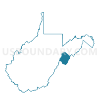
Voting District 13, Pendleton County, West Virginia
About
Outline

Summary
| Unique Area Identifier | 691663 |
| Name | Voting District 13 |
| County | Pendleton County |
| State | West Virginia |
| Area (square miles) | 39.43 |
| Land Area (square miles) | 39.42 |
| Water Area (square miles) | 0.00 |
| % of Land Area | 100.00 |
| % of Water Area | 0.00 |
| Latitude of the Internal Point | 38.90615430 |
| Longtitude of the Internal Point | -79.39167610 |
Maps


Graphs
Select a template below for downloading or customizing gragh for Voting District 13, Pendleton County, West Virginia


Neighbors
Neighoring Voting District (by Name) Neighboring Voting District on the Map
- Voting District 15, Pendleton County, WV
- Voting District 185, Randolph County, WV
- Voting District 7, Grant County, WV
Top 10 Neighboring County Subdivision (by Population) Neighboring County Subdivision on the Map
- Union district, Grant County, WV (3,539)
- Western district, Pendleton County, WV (2,566)
- Dry Fork district, Randolph County, WV (1,496)
Top 10 Neighboring Unified School District (by Population) Neighboring Unified School District on the Map
- Randolph County School District, WV (29,405)
- Grant County School District, WV (11,937)
- Pendleton County School District, WV (7,695)
Top 10 Neighboring State Legislative District Lower Chamber (by Population) Neighboring State Legislative District Lower Chamber on the Map
Top 10 Neighboring State Legislative District Upper Chamber (by Population) Neighboring State Legislative District Upper Chamber on the Map
Top 10 Neighboring 111th Congressional District (by Population) Neighboring 111th Congressional District on the Map
Top 10 Neighboring Census Tract (by Population) Neighboring Census Tract on the Map
- Census Tract 9695, Grant County, WV (3,892)
- Census Tract 9663, Randolph County, WV (3,057)
- Census Tract 9704, Pendleton County, WV (1,786)