


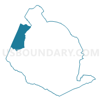
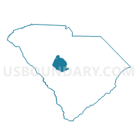
010 Voting District, Lexington County, South Carolina
About
Outline

Summary
| Unique Area Identifier | 666342 |
| Name | 010 Voting District |
| County | Lexington County |
| State | South Carolina |
| Area (square miles) | 43.38 |
| Land Area (square miles) | 37.98 |
| Water Area (square miles) | 5.40 |
| % of Land Area | 87.55 |
| % of Water Area | 12.45 |
| Latitude of the Internal Point | 34.01417140 |
| Longtitude of the Internal Point | -81.46528330 |
Maps

Graphs
Select a template below for downloading or customizing gragh for 010 Voting District, Lexington County, South Carolina


Neighbors
Neighoring Voting District (by Name) Neighboring Voting District on the Map
- 001 Voting District, Lexington County, SC
- 006 Voting District, Lexington County, SC
- 011 Voting District, Lexington County, SC
- 012 Voting District, Lexington County, SC
- 015 Voting District, Lexington County, SC
- 061 Voting District, Lexington County, SC
- Delmar Voting District, Saluda County, SC
- Fairview Voting District, Newberry County, SC
- Holly Voting District, Saluda County, SC
- Holstons Voting District, Saluda County, SC
- O'Neal Voting District, Newberry County, SC
Top 10 Neighboring County Subdivision (by Population) Neighboring County Subdivision on the Map
- Gilbert CCD, Lexington County, SC (20,028)
- Chapin CCD, Lexington County, SC (14,228)
- Prosperity CCD, Newberry County, SC (10,746)
- Batesburg-Leesville CCD, Lexington County, SC (9,176)
- Batesburg-Leesville CCD, Saluda County, SC (4,854)
Top 10 Neighboring Place (by Population) Neighboring Place on the Map
Top 10 Neighboring Unified School District (by Population) Neighboring Unified School District on the Map
- Lexington School District 1, SC (121,030)
- Newberry County School District, SC (37,508)
- Saluda County School District, SC (15,200)
- Lexington School District 3, SC (13,248)
Top 10 Neighboring State Legislative District Lower Chamber (by Population) Neighboring State Legislative District Lower Chamber on the Map
- State House District 87, SC (47,453)
- State House District 40, SC (34,899)
- State House District 85, SC (34,760)
- State House District 39, SC (34,678)
Top 10 Neighboring State Legislative District Upper Chamber (by Population) Neighboring State Legislative District Upper Chamber on the Map
- State Senate District 23, SC (113,071)
- State Senate District 18, SC (95,143)
- State Senate District 26, SC (91,335)
Top 10 Neighboring 111th Congressional District (by Population) Neighboring 111th Congressional District on the Map
- Congressional District 2, SC (825,324)
- Congressional District 5, SC (767,773)
- Congressional District 3, SC (722,675)
Top 10 Neighboring Census Tract (by Population) Neighboring Census Tract on the Map
- Census Tract 9506.02, Newberry County, SC (5,877)
- Census Tract 9603, Saluda County, SC (4,854)
- Census Tract 213.04, Lexington County, SC (3,764)
- Census Tract 213.03, Lexington County, SC (3,272)
- Census Tract 214.04, Lexington County, SC (3,109)
- Census Tract 212.05, Lexington County, SC (2,854)
- Census Tract 213.05, Lexington County, SC (2,852)