


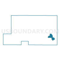
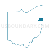
PRECINCT SPT 1, Mahoning County, Ohio
About
Outline

Summary
| Unique Area Identifier | 649618 |
| Name | PRECINCT SPT 1 |
| County | Mahoning County |
| State | Ohio |
| Area (square miles) | 5.34 |
| Land Area (square miles) | 5.18 |
| Water Area (square miles) | 0.16 |
| % of Land Area | 96.96 |
| % of Water Area | 3.04 |
| Latitude of the Internal Point | 40.96603350 |
| Longtitude of the Internal Point | -80.58558440 |
Maps

Graphs
Select a template below for downloading or customizing gragh for PRECINCT SPT 1, Mahoning County, Ohio


Neighbors
Neighoring Voting District (by Name) Neighboring Voting District on the Map
- PRECINCT NMV 1, Mahoning County, OH
- PRECINCT NMV 2, Mahoning County, OH
- PRECINCT POT 16, Mahoning County, OH
- PRECINCT POT 5, Mahoning County, OH
- PRECINCT SPT 2, Mahoning County, OH
- PRECINCT SPT 4, Mahoning County, OH
- PRECINCT SPT 5, Mahoning County, OH
- PRECINCT SPT 6, Mahoning County, OH
- PRECINCT SPT 7, Mahoning County, OH
Top 10 Neighboring County Subdivision (by Population) Neighboring County Subdivision on the Map
- Poland township, Mahoning County, OH (14,960)
- Springfield township, Mahoning County, OH (6,703)
- New Middletown village, Mahoning County, OH (1,621)