


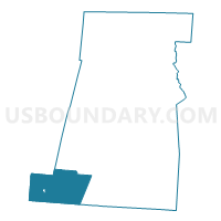
PRECINCT STOKES, Madison County, Ohio
About
Outline

Summary
| Unique Area Identifier | 649433 |
| Name | PRECINCT STOKES |
| County | Madison County |
| State | Ohio |
| Area (square miles) | 34.56 |
| Land Area (square miles) | 34.56 |
| Water Area (square miles) | 0.00 |
| % of Land Area | 100.00 |
| % of Water Area | 0.00 |
| Latitude of the Internal Point | 39.74462440 |
| Longtitude of the Internal Point | -83.57150330 |
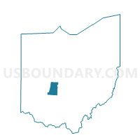
Maps

Graphs
Select a template below for downloading or customizing gragh for PRECINCT STOKES, Madison County, Ohio


Neighbors
Neighoring Voting District (by Name) Neighboring Voting District on the Map
- Voting District CHAS TWP, Clark County, OH
- JEFFERSON NORTH Voting District, Fayette County, OH
- PAINT Voting District, Fayette County, OH
- PRECINCT PAINT, Madison County, OH
- PRECINCT RANGE, Madison County, OH
- PRECINCT ROSS TWP 475, Greene County, OH
- PRECINCT SOUTH SOLON, Madison County, OH
Top 10 Neighboring County Subdivision (by Population) Neighboring County Subdivision on the Map
- Jefferson township, Fayette County, OH (2,636)
- Madison township, Clark County, OH (2,543)
- Paint township, Fayette County, OH (1,975)
- Range township, Madison County, OH (979)
- Ross township, Greene County, OH (750)
- Stokes township, Madison County, OH (679)
- Paint township, Madison County, OH (556)
Top 10 Neighboring Place (by Population) Neighboring Place on the Map
Top 10 Neighboring Unified School District (by Population) Neighboring Unified School District on the Map
- Miami Trace Local School District, OH (15,618)
- Madison-Plains Local School District, OH (11,154)
- Greeneview Local School District, OH (8,148)
- Southeastern Local School District, OH (4,272)
Top 10 Neighboring State Legislative District Lower Chamber (by Population) Neighboring State Legislative District Lower Chamber on the Map
Top 10 Neighboring State Legislative District Upper Chamber (by Population) Neighboring State Legislative District Upper Chamber on the Map
Top 10 Neighboring 111th Congressional District (by Population) Neighboring 111th Congressional District on the Map
Top 10 Neighboring Census Tract (by Population) Neighboring Census Tract on the Map
- Census Tract 2601, Greene County, OH (6,250)
- Census Tract 9258, Fayette County, OH (3,976)
- Census Tract 9259, Fayette County, OH (3,557)
- Census Tract 33.02, Clark County, OH (2,543)
- Census Tract 413, Madison County, OH (2,214)