


PRECINCT MONROE, Madison County, Ohio
About
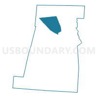
Outline

Summary
| Unique Area Identifier | 649410 |
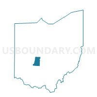
| Name | PRECINCT MONROE |
| County | Madison County |
| State | Ohio |
| Area (square miles) | 22.85 |
| Land Area (square miles) | 22.85 |
| Water Area (square miles) | 0.00 |
| % of Land Area | 100.00 |
| % of Water Area | 0.00 |
| Latitude of the Internal Point | 40.02161970 |
| Longtitude of the Internal Point | -83.40872790 |
Maps

Graphs
Select a template below for downloading or customizing gragh for PRECINCT MONROE, Madison County, Ohio


Neighbors
Neighoring Voting District (by Name) Neighboring Voting District on the Map
- PRECINCT CANAAN WEST, Madison County, OH
- PRECINCT DARBY, Madison County, OH
- PRECINCT DEERCREEK, Madison County, OH
- PRECINCT JEFFERSON TWP 1, Madison County, OH
- PRECINCT PIKE, Madison County, OH
- PRECINCT SOMERFORD, Madison County, OH
Top 10 Neighboring County Subdivision (by Population) Neighboring County Subdivision on the Map
- Jefferson township, Madison County, OH (7,140)
- Darby township, Madison County, OH (4,226)
- Somerford township, Madison County, OH (2,898)
- Canaan township, Madison County, OH (2,567)
- Monroe township, Madison County, OH (1,719)
- Deer Creek township, Madison County, OH (933)
- Pike township, Madison County, OH (580)
Top 10 Neighboring Place (by Population) Neighboring Place on the Map
Top 10 Neighboring Unified School District (by Population) Neighboring Unified School District on the Map
- Jonathan Alder Local School District, OH (12,073)
- Jefferson Local School District, OH (7,050)
- Fairbanks Local School District, OH (6,583)
- Mechanicsburg Exempted Village School District, OH (4,953)
Top 10 Neighboring State Legislative District Lower Chamber (by Population) Neighboring State Legislative District Lower Chamber on the Map
Top 10 Neighboring State Legislative District Upper Chamber (by Population) Neighboring State Legislative District Upper Chamber on the Map
Top 10 Neighboring 111th Congressional District (by Population) Neighboring 111th Congressional District on the Map
Top 10 Neighboring Census Tract (by Population) Neighboring Census Tract on the Map
- Census Tract 402.02, Madison County, OH (2,655)
- Census Tract 404, Madison County, OH (2,612)
- Census Tract 401.01, Madison County, OH (2,282)