


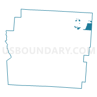
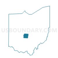
PLAIN-A Voting District, Franklin County, Ohio
About
Outline

Summary
| Unique Area Identifier | 646509 |
| Name | PLAIN-A Voting District |
| County | Franklin County |
| State | Ohio |
| Area (square miles) | 3.43 |
| Land Area (square miles) | 3.37 |
| Water Area (square miles) | 0.06 |
| % of Land Area | 98.34 |
| % of Water Area | 1.66 |
| Latitude of the Internal Point | 40.06219100 |
| Longtitude of the Internal Point | -82.78445260 |
Maps

Graphs
Select a template below for downloading or customizing gragh for PLAIN-A Voting District, Franklin County, Ohio


Neighbors
Neighoring Voting District (by Name) Neighboring Voting District on the Map
- COLS 73-D Voting District, Franklin County, OH
- COLS 73-G Voting District, Franklin County, OH
- COLS 73-H Voting District, Franklin County, OH
- COLS 82-D Voting District, Franklin County, OH
- COLS 82-E Voting District, Franklin County, OH
- COLS 82-G Voting District, Franklin County, OH
- GAH 2-H Voting District, Franklin County, OH
- GAH 4-A Voting District, Franklin County, OH
- JEFFERSON-A Voting District, Franklin County, OH
- JEFFERSON-C Voting District, Franklin County, OH
- JEFFERSON-F Voting District, Franklin County, OH
- JERSEY TOWNSHIP A Voting District, Licking County, OH
- JERSEY TOWNSHIP B Voting District, Licking County, OH
- NEW ALBANY-A Voting District, Franklin County, OH
- NEW ALBANY-B Voting District, Franklin County, OH
- NEW ALBANY-C Voting District, Franklin County, OH
- NEW ALBANY-D Voting District, Franklin County, OH
- NEW ALBANY-E Voting District, Franklin County, OH
- PATASKALA 2-A Voting District, Licking County, OH
- PLAIN-B Voting District, Franklin County, OH
Top 10 Neighboring County Subdivision (by Population) Neighboring County Subdivision on the Map
- Columbus city, Franklin County, OH (770,122)
- Mifflin township, Franklin County, OH (35,710)
- Pataskala city, Licking County, OH (14,962)
- Jefferson township, Franklin County, OH (10,972)
- Plain township, Franklin County, OH (9,829)
- Blendon township, Franklin County, OH (9,069)
- Jersey township, Licking County, OH (2,740)
Top 10 Neighboring Place (by Population) Neighboring Place on the Map
- Columbus city, OH (787,033)
- Gahanna city, OH (33,248)
- Pataskala city, OH (14,962)
- New Albany village, OH (7,724)
Top 10 Neighboring Unified School District (by Population) Neighboring Unified School District on the Map
- Columbus City School District, OH (500,906)
- Gahanna-Jefferson City School District, OH (44,476)
- Licking Heights Local School District, OH (22,242)
- New Albany-Plain Local School District, OH (19,564)
Top 10 Neighboring State Legislative District Lower Chamber (by Population) Neighboring State Legislative District Lower Chamber on the Map
- State House District 19, OH (157,070)
- State House District 20, OH (132,198)
- State House District 71, OH (126,986)
Top 10 Neighboring State Legislative District Upper Chamber (by Population) Neighboring State Legislative District Upper Chamber on the Map
Top 10 Neighboring 111th Congressional District (by Population) Neighboring 111th Congressional District on the Map
Top 10 Neighboring Census Tract (by Population) Neighboring Census Tract on the Map
- Census Tract 73.93, Franklin County, OH (8,742)
- Census Tract 72.10, Franklin County, OH (8,200)
- Census Tract 71.32, Franklin County, OH (7,422)
- Census Tract 7559, Licking County, OH (6,882)
- Census Tract 72.09, Franklin County, OH (5,706)
- Census Tract 7556, Licking County, OH (5,186)
- Census Tract 72.07, Franklin County, OH (4,173)
- Census Tract 72.05, Franklin County, OH (3,710)
- Census Tract 72.03, Franklin County, OH (3,233)
- Census Tract 73.94, Franklin County, OH (2,806)