


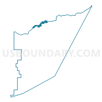
Precinct 12, Storey County, Nevada
About
Outline

Summary
| Unique Area Identifier | 615463 |
| Name | Precinct 12 |
| County | Storey County |
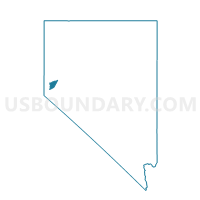
| State | Nevada |
| Area (square miles) | 1.86 |
| Land Area (square miles) | 1.73 |
| Water Area (square miles) | 0.13 |
| % of Land Area | 92.78 |
| % of Water Area | 7.22 |
| Latitude of the Internal Point | 39.55162600 |
| Longtitude of the Internal Point | -119.55189380 |
Maps

Graphs
Select a template below for downloading or customizing gragh for Precinct 12, Storey County, Nevada


Neighbors
Neighoring Voting District (by Name) Neighboring Voting District on the Map
- Precinct 11, Storey County, NV
- Precinct 13, Storey County, NV
- Precinct 3, Storey County, NV
- Precinct 7, Storey County, NV
- Precinct 8, Storey County, NV
- Precinct No. 7400, Washoe County, NV
- Precinct No. 7412, Washoe County, NV
- Precinct No. 9400, Washoe County, NV
Top 10 Neighboring County Subdivision (by Population) Neighboring County Subdivision on the Map
Top 10 Neighboring Unified School District (by Population) Neighboring Unified School District on the Map
Top 10 Neighboring State Legislative District Lower Chamber (by Population) Neighboring State Legislative District Lower Chamber on the Map
- Assembly District 32, NV (80,177)
- Assembly District 38, NV (66,836)
- Assembly District 35, NV (51,108)