


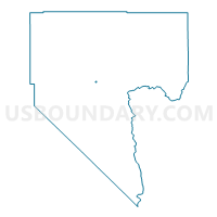
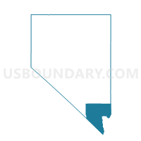
Precinct 2426, Clark County, Nevada
About
Outline

Summary
| Unique Area Identifier | 614746 |
| Name | Precinct 2426 |
| County | Clark County |
| State | Nevada |
| Area (square miles) | 0.39 |
| Land Area (square miles) | 0.39 |
| Water Area (square miles) | 0.00 |
| % of Land Area | 100.00 |
| % of Water Area | 0.00 |
| Latitude of the Internal Point | 36.19089340 |
| Longtitude of the Internal Point | -115.12240470 |
Maps

Graphs
Select a template below for downloading or customizing gragh for Precinct 2426, Clark County, Nevada


Neighbors
Neighoring Voting District (by Name) Neighboring Voting District on the Map
- Precinct 2425, Clark County, NV
- Precinct 4386, Clark County, NV
- Precinct 4387, Clark County, NV
- Precinct 4393, Clark County, NV
- Precinct 4463, Clark County, NV
Top 10 Neighboring County Subdivision (by Population) Neighboring County Subdivision on the Map
Top 10 Neighboring Place (by Population) Neighboring Place on the Map
Top 10 Neighboring Unified School District (by Population) Neighboring Unified School District on the Map
Top 10 Neighboring State Legislative District Lower Chamber (by Population) Neighboring State Legislative District Lower Chamber on the Map
- Assembly District 6, NV (44,947)
- Assembly District 28, NV (44,394)
- Assembly District 11, NV (41,753)
Top 10 Neighboring State Legislative District Upper Chamber (by Population) Neighboring State Legislative District Upper Chamber on the Map
Top 10 Neighboring 111th Congressional District (by Population) Neighboring 111th Congressional District on the Map
Top 10 Neighboring Census Tract (by Population) Neighboring Census Tract on the Map
- Census Tract 41, Clark County, NV (5,840)
- Census Tract 5.10, Clark County, NV (5,503)
- Census Tract 38, Clark County, NV (4,574)
- Census Tract 43.02, Clark County, NV (4,175)
- Census Tract 40, Clark County, NV (3,634)
- Census Tract 4.02, Clark County, NV (3,491)
- Census Tract 5.25, Clark County, NV (2,758)