


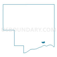
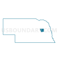
Columbus Ward 2B, Platte County, Nebraska
About
Outline

Summary
| Unique Area Identifier | 613723 |
| Name | Columbus Ward 2B |
| County | Platte County |
| State | Nebraska |
| Area (square miles) | 1.14 |
| Land Area (square miles) | 1.01 |
| Water Area (square miles) | 0.13 |
| % of Land Area | 88.48 |
| % of Water Area | 11.52 |
| Latitude of the Internal Point | 41.42286580 |
| Longtitude of the Internal Point | -97.37578320 |
Maps

Graphs
Select a template below for downloading or customizing gragh for Columbus Ward 2B, Platte County, Nebraska


Neighbors
Neighoring Voting District (by Name) Neighboring Voting District on the Map
- Columbus Twp B Precinct, Platte County, NE
- Columbus Ward 2A, Platte County, NE
- Columbus Ward 2C, Platte County, NE
Top 10 Neighboring County Subdivision (by Population) Neighboring County Subdivision on the Map
Top 10 Neighboring Place (by Population) Neighboring Place on the Map
Top 10 Neighboring Unified School District (by Population) Neighboring Unified School District on the Map
Top 10 Neighboring State Legislative District Upper Chamber (by Population) Neighboring State Legislative District Upper Chamber on the Map
Top 10 Neighboring 111th Congressional District (by Population) Neighboring 111th Congressional District on the Map
Top 10 Neighboring Census Tract (by Population) Neighboring Census Tract on the Map
- Census Tract 9655, Platte County, NE (5,427)
- Census Tract 9656, Platte County, NE (4,392)
- Census Tract 9657, Platte County, NE (3,188)