


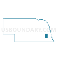
Middle Creek Precinct, Lancaster County, Nebraska
About
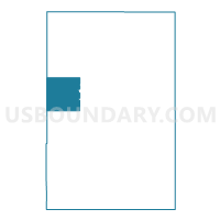
Outline

Summary
| Unique Area Identifier | 613365 |
| Name | Middle Creek Precinct |
| County | Lancaster County |
| State | Nebraska |
| Area (square miles) | 35.76 |
| Land Area (square miles) | 34.73 |
| Water Area (square miles) | 1.03 |
| % of Land Area | 97.12 |
| % of Water Area | 2.88 |
| Latitude of the Internal Point | 40.82799570 |
| Longtitude of the Internal Point | -96.85507990 |
Maps

Graphs
Select a template below for downloading or customizing gragh for Middle Creek Precinct, Lancaster County, Nebraska


Neighbors
Neighoring Voting District (by Name) Neighboring Voting District on the Map
- 1F-1 Precinct, Lancaster County, NE
- 1F-2 Precinct, Lancaster County, NE
- 1F-3 Precinct, Lancaster County, NE
- 2D-3 Precinct, Lancaster County, NE
- Denton Precinct, Lancaster County, NE
- Elk Precinct, Lancaster County, NE
- Garfield 2 Precinct, Lancaster County, NE
- H Precinct, Seward County, NE
- I Precinct, Seward County, NE
- Oak 2 Precinct, Lancaster County, NE
- Yankee Hill North Precinct, Lancaster County, NE
Top 10 Neighboring County Subdivision (by Population) Neighboring County Subdivision on the Map
- Lincoln city, Lancaster County, NE (258,379)
- Yankee Hill precinct, Lancaster County, NE (1,812)
- Denton precinct, Lancaster County, NE (1,335)
- Elk precinct, Lancaster County, NE (1,276)
- Middle Creek precinct, Lancaster County, NE (908)
- Oak precinct, Lancaster County, NE (855)
- Precinct H, Seward County, NE (781)
- Precinct I, Seward County, NE (708)
- Lincoln precinct, Lancaster County, NE (550)
- Precinct P, Seward County, NE (473)
Top 10 Neighboring Place (by Population) Neighboring Place on the Map
Top 10 Neighboring Unified School District (by Population) Neighboring Unified School District on the Map
- Lincoln Public Schools, NE (260,793)
- Seward Public Schools, NE (10,431)
- Milford Public Schools, NE (4,105)
- Malcolm Public Schools, NE (2,102)
Top 10 Neighboring State Legislative District Upper Chamber (by Population) Neighboring State Legislative District Upper Chamber on the Map
- State Senate District 21, NE (44,532)
- State Senate District 30, NE (39,073)
- State Senate District 24, NE (34,230)
Top 10 Neighboring 111th Congressional District (by Population) Neighboring 111th Congressional District on the Map
Top 10 Neighboring Census Tract (by Population) Neighboring Census Tract on the Map
- Census Tract 34.01, Lancaster County, NE (5,805)
- Census Tract 9604, Seward County, NE (4,988)
- Census Tract 102.02, Lancaster County, NE (4,388)
- Census Tract 9601, Seward County, NE (4,378)
- Census Tract 103, Lancaster County, NE (3,855)
- Census Tract 33.02, Lancaster County, NE (3,830)
- Census Tract 32.02, Lancaster County, NE (3,156)
- Census Tract 36.04, Lancaster County, NE (2,787)
Top 10 Neighboring 5-Digit ZIP Code Tabulation Area (by Population) Neighboring 5-Digit ZIP Code Tabulation Area on the Map
- 68522, NE (12,728)
- 68528, NE (6,285)
- 68524, NE (5,983)
- 68339, NE (1,311)
- 68402, NE (1,210)
- 68423, NE (898)
- 68532, NE (493)