


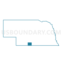
Beaver City Precinct, Furnas County, Nebraska
About
Outline

Summary
| Unique Area Identifier | 613152 |
| Name | Beaver City Precinct |
| County | Furnas County |
| State | Nebraska |
| Area (square miles) | 143.73 |
| Land Area (square miles) | 143.73 |
| Water Area (square miles) | 0.00 |
| % of Land Area | 100.00 |
| % of Water Area | 0.00 |
| Latitude of the Internal Point | 40.08878790 |
| Longtitude of the Internal Point | -99.74216810 |
Maps

Graphs
Select a template below for downloading or customizing gragh for Beaver City Precinct, Furnas County, Nebraska


Neighbors
Neighoring Voting District (by Name) Neighboring Voting District on the Map
- Almena Township Voting District, Norton County, KS
- Arapahoe Precinct, Furnas County, NE
- Center Precinct 1, Norton County, KS
- Edison Precinct, Furnas County, NE
- Harrison Township Voting District, Norton County, KS
- Hendley Precinct, Furnas County, NE
- Oxford Precinct, Furnas County, NE
- Oxford Precinct, Harlan County, NE
- Stamford Precinct, Harlan County, NE
Top 10 Neighboring County Subdivision (by Population) Neighboring County Subdivision on the Map
- Center-District 1 township, Norton County, KS (1,393)
- Arapahoe precinct, Furnas County, NE (1,200)
- Oxford precinct, Furnas County, NE (649)
- Beaver City city, Furnas County, NE (609)
- Almena-District 4 township, Norton County, KS (566)
- Emerson township, Harlan County, NE (277)
- Sappa township, Harlan County, NE (265)
- Edison precinct, Furnas County, NE (237)
- Hendley precinct, Furnas County, NE (161)
- Hollinger precinct, Furnas County, NE (114)
Top 10 Neighboring Place (by Population) Neighboring Place on the Map
Top 10 Neighboring Unified School District (by Population) Neighboring Unified School District on the Map
- Norton Community Schools Unified School District 211, KS (4,473)
- Southern Valley Schools, NE (2,895)
- Alma Public Schools, NE (1,885)
- Northern Valley Unified School District 212, KS (897)
Top 10 Neighboring State Legislative District Lower Chamber (by Population) Neighboring State Legislative District Lower Chamber on the Map
Top 10 Neighboring State Legislative District Upper Chamber (by Population) Neighboring State Legislative District Upper Chamber on the Map
- State Senate District 40, KS (61,332)
- State Senate District 44, NE (33,011)
- State Senate District 38, NE (32,734)
Top 10 Neighboring 111th Congressional District (by Population) Neighboring 111th Congressional District on the Map
Top 10 Neighboring Census Tract (by Population) Neighboring Census Tract on the Map
- Census Tract 9517, Norton County, KS (5,671)
- Census Tract 9639, Furnas County, NE (4,959)
- Census Tract 9642, Harlan County, NE (3,423)
Top 10 Neighboring 5-Digit ZIP Code Tabulation Area (by Population) Neighboring 5-Digit ZIP Code Tabulation Area on the Map
- 67654, KS (4,362)
- 68967, NE (1,142)
- 68926, NE (783)
- 67622, KS (599)
- 68977, NE (342)
- 67647, KS (256)
- 68936, NE (243)