


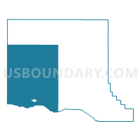
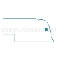
Ridgely-Union-Cotterell Precinct- Pleasant Valley, Dodge County, Nebraska
About
Outline

Summary
| Unique Area Identifier | 612751 |
| Name | Ridgely-Union-Cotterell Precinct- Pleasant Valley |
| County | Dodge County |
| State | Nebraska |
| Area (square miles) | 174.85 |
| Land Area (square miles) | 170.45 |
| Water Area (square miles) | 4.39 |
| % of Land Area | 97.49 |
| % of Water Area | 2.51 |
| Latitude of the Internal Point | 41.54649820 |
| Longtitude of the Internal Point | -96.78544140 |
Maps

Graphs
Select a template below for downloading or customizing gragh for Ridgely-Union-Cotterell Precinct- Pleasant Valley, Dodge County, Nebraska


Neighbors
Neighoring Voting District (by Name) Neighboring Voting District on the Map
- 1 Precinct, Colfax County, NE
- 6 Precinct, Colfax County, NE
- Cedar Bluffs Precinct, Saunders County, NE
- Cuming-Everett Precinct, Dodge County, NE
- Maple-Nickerson Precinct, Dodge County, NE
- North Bend Village Precinct, Dodge County, NE
- Pebble Precinct, Dodge County, NE
- Platte East Precinct, Dodge County, NE
- Platte Precinct, Butler County, NE
- Platte West Precinct, Dodge County, NE
- Prague Precinct, Saunders County, NE
- Webster Precinct, Dodge County, NE
Top 10 Neighboring County Subdivision (by Population) Neighboring County Subdivision on the Map
- Platte township, Dodge County, NE (2,235)
- North Bend city, Dodge County, NE (1,177)
- Webster township, Dodge County, NE (886)
- North Cedar township, Saunders County, NE (786)
- Lincoln precinct, Colfax County, NE (753)
- Pebble township, Dodge County, NE (489)
- Cotterell township, Dodge County, NE (403)
- Morse Bluff township, Saunders County, NE (381)
- Maple township, Dodge County, NE (322)
- Union township, Dodge County, NE (253)
Top 10 Neighboring Place (by Population) Neighboring Place on the Map
Top 10 Neighboring Unified School District (by Population) Neighboring Unified School District on the Map
- Schuyler Community Schools, NE (8,316)
- North Bend Central Public Schools, NE (2,884)
- Scribner-Snyder Community Schools, NE (1,821)
- Cedar Bluffs Public Schools, NE (1,177)
- Dodge Public Schools, NE (1,109)
- Howells Public Schools, NE (1,078)
Top 10 Neighboring State Legislative District Upper Chamber (by Population) Neighboring State Legislative District Upper Chamber on the Map
- State Senate District 23, NE (40,859)
- State Senate District 15, NE (36,691)
- State Senate District 22, NE (35,193)
Top 10 Neighboring 111th Congressional District (by Population) Neighboring 111th Congressional District on the Map
Top 10 Neighboring Census Tract (by Population) Neighboring Census Tract on the Map
- Census Tract 9682, Saunders County, NE (5,485)
- Census Tract 9636, Dodge County, NE (5,026)
- Census Tract 9676, Butler County, NE (3,327)
- Census Tract 9681, Saunders County, NE (3,210)
- Census Tract 9637, Dodge County, NE (2,588)
- Census Tract 9646, Colfax County, NE (2,225)
- Census Tract 9647, Colfax County, NE (1,774)
Top 10 Neighboring 5-Digit ZIP Code Tabulation Area (by Population) Neighboring 5-Digit ZIP Code Tabulation Area on the Map
- 68661, NE (7,282)
- 68649, NE (1,835)
- 68031, NE (1,745)
- 68057, NE (1,544)
- 68633, NE (1,179)
- 68015, NE (1,151)
- 68621, NE (517)
- 68648, NE (484)
- 68036, NE (402)
- 68659, NE (215)