


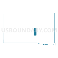
Lexington 2nd Precinct, Dawson County, Nebraska
About
Outline

Summary
| Unique Area Identifier | 612695 |
| Name | Lexington 2nd Precinct |
| County | Dawson County |
| State | Nebraska |
| Area (square miles) | 12.04 |
| Land Area (square miles) | 12.04 |
| Water Area (square miles) | 0.00 |
| % of Land Area | 100.00 |
| % of Water Area | 0.00 |
| Latitude of the Internal Point | 40.83006370 |
| Longtitude of the Internal Point | -99.73006810 |
Maps

Graphs
Select a template below for downloading or customizing gragh for Lexington 2nd Precinct, Dawson County, Nebraska


Neighbors
Neighoring Voting District (by Name) Neighboring Voting District on the Map
- Coyote Precinct, Dawson County, NE
- Grant Precinct, Dawson County, NE
- Lexington 1st Precinct, Dawson County, NE
- Lexington 3rd Precinct, Dawson County, NE
- Lexington 4th Precinct, Dawson County, NE
Top 10 Neighboring County Subdivision (by Population) Neighboring County Subdivision on the Map
- Lexington city, Dawson County, NE (10,230)
- Lexington precinct, Dawson County, NE (925)
- Grant precinct, Dawson County, NE (627)
- Coyote precinct, Dawson County, NE (550)
Top 10 Neighboring Place (by Population) Neighboring Place on the Map
Top 10 Neighboring Unified School District (by Population) Neighboring Unified School District on the Map
Top 10 Neighboring State Legislative District Upper Chamber (by Population) Neighboring State Legislative District Upper Chamber on the Map
Top 10 Neighboring 111th Congressional District (by Population) Neighboring 111th Congressional District on the Map
Top 10 Neighboring Census Tract (by Population) Neighboring Census Tract on the Map
- Census Tract 9685, Dawson County, NE (5,424)
- Census Tract 9684, Dawson County, NE (5,365)
- Census Tract 9680, Dawson County, NE (2,584)
- Census Tract 9681, Dawson County, NE (1,494)