


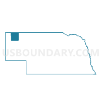
#5 Precinct, Dawes County, Nebraska
About
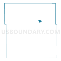
Outline

Summary
| Unique Area Identifier | 612684 |
| Name | #5 Precinct |
| County | Dawes County |
| State | Nebraska |
| Area (square miles) | 1.81 |
| Land Area (square miles) | 1.81 |
| Water Area (square miles) | 0.00 |
| % of Land Area | 100.00 |
| % of Water Area | 0.00 |
| Latitude of the Internal Point | 42.81802670 |
| Longtitude of the Internal Point | -103.00884480 |
Maps

Graphs
Select a template below for downloading or customizing gragh for #5 Precinct, Dawes County, Nebraska


Neighbors
Neighoring Voting District (by Name) Neighboring Voting District on the Map
- #1 Precinct, Dawes County, NE
- #2 Precinct, Dawes County, NE
- #3 Precinct, Dawes County, NE
- #4 Precinct, Dawes County, NE
- #6 Precinct, Dawes County, NE
- #8 Precinct, Dawes County, NE
- Precinct 4C, Dawes County, NE
Top 10 Neighboring County Subdivision (by Population) Neighboring County Subdivision on the Map
- Precinct 04, Dawes County, NE (1,557)
- Precinct 05, Dawes County, NE (1,539)
- Precinct 02, Dawes County, NE (1,163)
- Precinct 03, Dawes County, NE (1,103)
- Precinct 06, Dawes County, NE (640)
- Precinct 01, Dawes County, NE (582)
- Precinct 08, Dawes County, NE (466)