


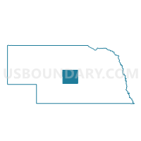
East Center Precinct, Custer County, Nebraska
About
Outline

Summary
| Unique Area Identifier | 612651 |
| Name | East Center Precinct |
| County | Custer County |
| State | Nebraska |
| Area (square miles) | 53.86 |
| Land Area (square miles) | 53.86 |
| Water Area (square miles) | 0.00 |
| % of Land Area | 100.00 |
| % of Water Area | 0.00 |
| Latitude of the Internal Point | 41.26307920 |
| Longtitude of the Internal Point | -99.63440920 |
Maps

Graphs
Select a template below for downloading or customizing gragh for East Center Precinct, Custer County, Nebraska


Neighbors
Neighoring Voting District (by Name) Neighboring Voting District on the Map
- Berwyn Precinct, Custer County, NE
- Custer Precinct, Custer County, NE
- Loup Precinct, Custer County, NE
- Ryno Precinct, Custer County, NE
- South Rural Broken Bow Precinct, Custer County, NE
- Wood River Precinct, Custer County, NE
Top 10 Neighboring County Subdivision (by Population) Neighboring County Subdivision on the Map
- Broken Bow township, Custer County, NE (769)
- Wood River township, Custer County, NE (326)
- Berwyn township, Custer County, NE (232)
- Loup township, Custer County, NE (129)
- Custer township, Custer County, NE (101)
- Ryno township, Custer County, NE (93)
- East Custer township, Custer County, NE (47)
Top 10 Neighboring Unified School District (by Population) Neighboring Unified School District on the Map
- Broken Bow Public Schools, NE (4,934)
- Callaway Public Schools, NE (1,294)
- Ansley Public Schools, NE (1,048)