


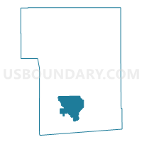
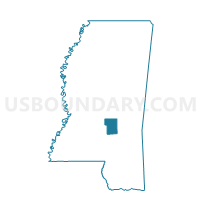
Mize Voting District, Smith County, Mississippi
About
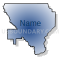
Outline

Summary
| Unique Area Identifier | 606680 |
| Name | Mize Voting District |
| County | Smith County |
| State | Mississippi |
| Area (square miles) | 24.37 |
| Land Area (square miles) | 24.36 |
| Water Area (square miles) | 0.01 |
| % of Land Area | 99.96 |
| % of Water Area | 0.04 |
| Latitude of the Internal Point | 31.87809060 |
| Longtitude of the Internal Point | -89.52144840 |
Maps

Graphs
Select a template below for downloading or customizing gragh for Mize Voting District, Smith County, Mississippi


Neighbors
Neighoring Voting District (by Name) Neighboring Voting District on the Map
- Ag Complex Voting District, Smith County, MS
- Center Ridge Voting District, Smith County, MS
- Shady Grove Voting District, Smith County, MS
- Taylorsville Voting District, Smith County, MS
- Zion Hill-New Haven Voting District, Smith County, MS
Top 10 Neighboring County Subdivision (by Population) Neighboring County Subdivision on the Map
- District 4, Smith County, MS (3,602)
- District 3, Smith County, MS (3,482)
- District 1, Smith County, MS (3,068)