


Parsons Ward 1 Precinct 3 Exclave, Labette County, Kansas
About
Outline

Summary
| Unique Area Identifier | 585578 |
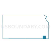
| Name | Parsons Ward 1 Precinct 3 Exclave |
| County | Labette County |
| State | Kansas |
| Area (square miles) | 0.23 |
| Land Area (square miles) | 0.22 |
| Water Area (square miles) | 0.01 |
| % of Land Area | 95.46 |
| % of Water Area | 4.54 |
| Latitude of the Internal Point | 37.38067070 |
| Longtitude of the Internal Point | -95.25576550 |
Maps


Graphs
Select a template below for downloading or customizing gragh for Parsons Ward 1 Precinct 3 Exclave, Labette County, Kansas


