


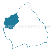
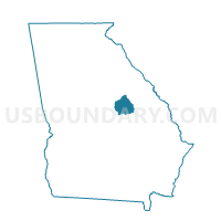
30399 - DEEPSTEP Voting District, Washington County, Georgia
About
Outline

Summary
| Unique Area Identifier | 563083 |
| Name | 30399 - DEEPSTEP Voting District |
| County | Washington County |
| State | Georgia |
| Area (square miles) | 78.64 |
| Land Area (square miles) | 77.86 |
| Water Area (square miles) | 0.78 |
| % of Land Area | 99.01 |
| % of Water Area | 0.99 |
| Latitude of the Internal Point | 33.03870020 |
| Longtitude of the Internal Point | -82.96886600 |
Maps

Graphs
Select a template below for downloading or customizing gragh for 30399 - DEEPSTEP Voting District, Washington County, Georgia


Neighbors
Neighoring Voting District (by Name) Neighboring Voting District on the Map
- 009MONT - EAST BALDWIN Voting District, Baldwin County, GA
- 1412B - LINTON B Voting District, Hancock County, GA
- 3031350 - WARTHEN Voting District, Washington County, GA
- 30388 - OCONEE Voting District, Washington County, GA
- 30397 - SANDERSVILLE Voting District, Washington County, GA
Top 10 Neighboring County Subdivision (by Population) Neighboring County Subdivision on the Map
- Sandersville CCD, Washington County, GA (9,739)
- Sparta CCD, Hancock County, GA (5,959)
- East Baldwin CCD, Baldwin County, GA (5,400)
- Warthen CCD, Washington County, GA (941)
- Deepstep CCD, Washington County, GA (891)
- Linton CCD, Hancock County, GA (828)
Top 10 Neighboring Place (by Population) Neighboring Place on the Map
Top 10 Neighboring Unified School District (by Population) Neighboring Unified School District on the Map
- Baldwin County School District, GA (45,720)
- Washington County School District, GA (21,187)
- Hancock County School District, GA (9,429)
Top 10 Neighboring State Legislative District Lower Chamber (by Population) Neighboring State Legislative District Lower Chamber on the Map
- State House District 141, GA (46,542)
- State House District 124, GA (45,898)
- State House District 142, GA (45,637)
Top 10 Neighboring State Legislative District Upper Chamber (by Population) Neighboring State Legislative District Upper Chamber on the Map
Top 10 Neighboring 111th Congressional District (by Population) Neighboring 111th Congressional District on the Map
Top 10 Neighboring Census Tract (by Population) Neighboring Census Tract on the Map
- Census Tract 4804, Hancock County, GA (6,768)
- Census Tract 9701, Baldwin County, GA (5,401)
- Census Tract 9503, Washington County, GA (4,752)
- Census Tract 4803, Hancock County, GA (2,661)
- Census Tract 9501, Washington County, GA (1,832)