


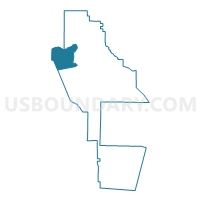
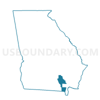
299408 - MILLWOOD Voting District, Ware County, Georgia
About
Outline

Summary
| Unique Area Identifier | 563067 |
| Name | 299408 - MILLWOOD Voting District |
| County | Ware County |
| State | Georgia |
| Area (square miles) | 52.82 |
| Land Area (square miles) | 52.15 |
| Water Area (square miles) | 0.67 |
| % of Land Area | 98.73 |
| % of Water Area | 1.27 |
| Latitude of the Internal Point | 31.23602590 |
| Longtitude of the Internal Point | -82.62757440 |
Maps

Graphs
Select a template below for downloading or customizing gragh for 299408 - MILLWOOD Voting District, Ware County, Georgia


Neighbors
Neighoring Voting District (by Name) Neighboring Voting District on the Map
- 0030002 - AXSON Voting District, Atkinson County, GA
- 065H - HOMERVILLE Voting District, Clinch County, GA
- 299404 - BEACH-BICKLEY Voting District, Ware County, GA
- 299405 - HAYWOOD Voting District, Ware County, GA
- 299407 - MANOR Voting District, Ware County, GA
- 299409 - WARESBORO Voting District, Ware County, GA
Top 10 Neighboring County Subdivision (by Population) Neighboring County Subdivision on the Map
- Waycross CCD, Ware County, GA (26,202)
- Waresboro CCD, Ware County, GA (7,718)
- Homerville CCD, Clinch County, GA (5,239)
- Dixie Union CCD, Ware County, GA (1,603)
- Axson CCD, Atkinson County, GA (1,245)
- Manor CCD, Ware County, GA (789)
Top 10 Neighboring Unified School District (by Population) Neighboring Unified School District on the Map
- Ware County School District, GA (36,312)
- Atkinson County School District, GA (8,375)
- Clinch County School District, GA (6,798)
Top 10 Neighboring State Legislative District Lower Chamber (by Population) Neighboring State Legislative District Lower Chamber on the Map
- State House District 176, GA (56,994)
- State House District 169, GA (51,596)
- State House District 177, GA (48,483)
Top 10 Neighboring State Legislative District Upper Chamber (by Population) Neighboring State Legislative District Upper Chamber on the Map
Top 10 Neighboring 111th Congressional District (by Population) Neighboring 111th Congressional District on the Map
Top 10 Neighboring Census Tract (by Population) Neighboring Census Tract on the Map
- Census Tract 9502, Ware County, GA (7,718)
- Census Tract 9508, Ware County, GA (6,398)
- Census Tract 9701, Clinch County, GA (5,239)
- Census Tract 9501, Ware County, GA (1,603)
- Census Tract 9603, Atkinson County, GA (1,245)