


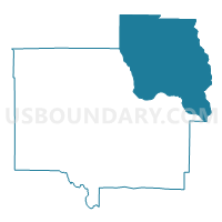
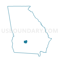
2873 - REBECCA Voting District, Turner County, Georgia
About
Outline

Summary
| Unique Area Identifier | 563002 |
| Name | 2873 - REBECCA Voting District |
| County | Turner County |
| State | Georgia |
| Area (square miles) | 70.14 |
| Land Area (square miles) | 69.21 |
| Water Area (square miles) | 0.92 |
| % of Land Area | 98.68 |
| % of Water Area | 1.32 |
| Latitude of the Internal Point | 31.78991340 |
| Longtitude of the Internal Point | -83.53228950 |
Maps

Graphs
Select a template below for downloading or customizing gragh for 2873 - REBECCA Voting District, Turner County, Georgia


Neighbors
Neighoring Voting District (by Name) Neighboring Voting District on the Map
- 0173 - WILLIAMSON MILL Voting District, Ben Hill County, GA
- 081ARABI - ARABI Voting District, Crisp County, GA
- 1550901 - IRWINVILLE Voting District, Irwin County, GA
- 1551670 - FLETCHER Voting District, Irwin County, GA
- 2871 - ASHBURN Voting District, Turner County, GA
- 2872 - SYCAMORE Voting District, Turner County, GA
- 3153A - PITTS #3 Voting District, Wilcox County, GA
Top 10 Neighboring County Subdivision (by Population) Neighboring County Subdivision on the Map
- Ashburn-Sycamore CCD, Turner County, GA (8,227)
- Irwinville CCD, Irwin County, GA (2,385)
- Rochelle CCD, Wilcox County, GA (2,213)
- Queensland CCD, Ben Hill County, GA (1,752)
- Arabi CCD, Crisp County, GA (1,639)
- Pitts CCD, Wilcox County, GA (1,490)
- Rebecca CCD, Turner County, GA (703)
Top 10 Neighboring Place (by Population) Neighboring Place on the Map
Top 10 Neighboring Unified School District (by Population) Neighboring Unified School District on the Map
- Crisp County School District, GA (23,439)
- Ben Hill County School District, GA (17,634)
- Irwin County School District, GA (9,538)
- Wilcox County School District, GA (9,255)
- Turner County School District, GA (8,930)
Top 10 Neighboring State Legislative District Lower Chamber (by Population) Neighboring State Legislative District Lower Chamber on the Map
- State House District 147, GA (54,428)
- State House District 154, GA (51,008)
- State House District 144, GA (51,000)
- State House District 153, GA (46,273)
Top 10 Neighboring State Legislative District Upper Chamber (by Population) Neighboring State Legislative District Upper Chamber on the Map
Top 10 Neighboring 111th Congressional District (by Population) Neighboring 111th Congressional District on the Map
Top 10 Neighboring Census Tract (by Population) Neighboring Census Tract on the Map
- Census Tract 9702, Turner County, GA (5,432)
- Census Tract 9703, Turner County, GA (3,498)
- Census Tract 9501, Irwin County, GA (2,385)
- Census Tract 9604, Wilcox County, GA (2,213)
- Census Tract 9602, Ben Hill County, GA (1,752)
- Census Tract 105, Crisp County, GA (1,639)
- Census Tract 9603, Wilcox County, GA (1,490)
Top 10 Neighboring 5-Digit ZIP Code Tabulation Area (by Population) Neighboring 5-Digit ZIP Code Tabulation Area on the Map
- 31015, GA (21,938)
- 31714, GA (6,474)
- 31079, GA (2,398)
- 31790, GA (2,078)
- 31072, GA (1,326)
- 31712, GA (1,263)
- 31783, GA (1,107)