


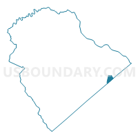
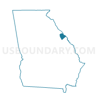
073090 - ABILENE BAPTIST Voting District, Columbia County, Georgia
About
Outline

Summary
| Unique Area Identifier | 560988 |
| Name | 073090 - ABILENE BAPTIST Voting District |
| County | Columbia County |
| State | Georgia |
| Area (square miles) | 1.01 |
| Land Area (square miles) | 1.01 |
| Water Area (square miles) | 0.00 |
| % of Land Area | 100.00 |
| % of Water Area | 0.00 |
| Latitude of the Internal Point | 33.50123050 |
| Longtitude of the Internal Point | -82.10064410 |
Maps

Graphs
Select a template below for downloading or customizing gragh for 073090 - ABILENE BAPTIST Voting District, Columbia County, Georgia


Neighbors
Neighoring Voting District (by Name) Neighboring Voting District on the Map
- 073076 - MARVIN METHODIST Voting District, Columbia County, GA
- 073080 - WESTSIDE BAPT CHURCH Voting District, Columbia County, GA
- 073110 - MTZ COL FIRE HD Voting District, Columbia County, GA
- 073115 - MARTINEZ BAPTIST Voting District, Columbia County, GA
- 073125 - CHURCH OF OUR SAVIOUR Voting District, Columbia County, GA
- 245306 - 306 Voting District, Richmond County, GA
- 245704 - 704 Voting District, Richmond County, GA
- 245706 - 706 Voting District, Richmond County, GA
Top 10 Neighboring County Subdivision (by Population) Neighboring County Subdivision on the Map
Top 10 Neighboring Place (by Population) Neighboring Place on the Map
Top 10 Neighboring Unified School District (by Population) Neighboring Unified School District on the Map
Top 10 Neighboring State Legislative District Lower Chamber (by Population) Neighboring State Legislative District Lower Chamber on the Map
- State House District 118, GA (60,824)
- State House District 120, GA (49,471)
- State House District 119, GA (46,117)
Top 10 Neighboring State Legislative District Upper Chamber (by Population) Neighboring State Legislative District Upper Chamber on the Map
Top 10 Neighboring 111th Congressional District (by Population) Neighboring 111th Congressional District on the Map
Top 10 Neighboring Census Tract (by Population) Neighboring Census Tract on the Map
- Census Tract 102.04, Richmond County, GA (13,436)
- Census Tract 302.03, Columbia County, GA (6,576)
- Census Tract 302.01, Columbia County, GA (6,450)
- Census Tract 101.05, Richmond County, GA (5,000)
- Census Tract 306.03, Columbia County, GA (4,162)
- Census Tract 301.06, Columbia County, GA (3,655)
- Census Tract 302.02, Columbia County, GA (2,963)