


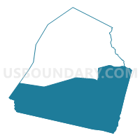
0431736 - CANDLER - 1736 Voting District, Candler County, Georgia
About
Outline

Summary
| Unique Area Identifier | 560453 |
| Name | 0431736 - CANDLER - 1736 Voting District |
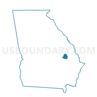
| County | Candler County |
| State | Georgia |
| Area (square miles) | 124.92 |
| Land Area (square miles) | 121.91 |
| Water Area (square miles) | 3.02 |
| % of Land Area | 97.58 |
| % of Water Area | 2.42 |
| Latitude of the Internal Point | 32.35569640 |
| Longtitude of the Internal Point | -82.07014630 |
Maps

Graphs
Select a template below for downloading or customizing gragh for 0431736 - CANDLER - 1736 Voting District, Candler County, Georgia


Neighbors
Neighoring Voting District (by Name) Neighboring Voting District on the Map
- 03111 - STATESBORO Voting District, Bulloch County, GA
- 0318 - SINKHOLE Voting District, Bulloch County, GA
- 0319 - REGISTER Voting District, Bulloch County, GA
- 0431685 - METTER - 1685 Voting District, Candler County, GA
- 1070050 - OAK PARK Voting District, Emanuel County, GA
- 1070058 - STILLMORE Voting District, Emanuel County, GA
- 1094 - UNDINE COURTHOUSE Voting District, Evans County, GA
- 2671 - COBBTOWN Voting District, Tattnall County, GA
- 2672 - LONGVIEW Voting District, Tattnall County, GA
- 2791192 - 1192 BLUE RIDGE Voting District, Toombs County, GA
Top 10 Neighboring County Subdivision (by Population) Neighboring County Subdivision on the Map
- Statesboro CCD, Bulloch County, GA (47,688)
- Vidalia-Lyons CCD, Toombs County, GA (23,867)
- Metter CCD, Candler County, GA (6,839)
- Twin City CCD, Emanuel County, GA (5,012)
- Collins CCD, Tattnall County, GA (3,601)
- North Evans CCD, Evans County, GA (3,122)
- Register CCD, Bulloch County, GA (2,542)
- Pulaski CCD, Candler County, GA (2,407)
- Aline CCD, Candler County, GA (1,752)
- Oak Park CCD, Emanuel County, GA (966)
Top 10 Neighboring Place (by Population) Neighboring Place on the Map
Top 10 Neighboring Unified School District (by Population) Neighboring Unified School District on the Map
- Bulloch County School District, GA (70,217)
- Tattnall County School District, GA (25,519)
- Emanuel County School District, GA (22,598)
- Toombs County School District, GA (16,901)
- Evans County School District, GA (11,000)
- Candler County School District, GA (10,998)
Top 10 Neighboring State Legislative District Lower Chamber (by Population) Neighboring State Legislative District Lower Chamber on the Map
- State House District 156, GA (51,000)
- State House District 155, GA (47,362)
- State House District 166, GA (46,202)
Top 10 Neighboring State Legislative District Upper Chamber (by Population) Neighboring State Legislative District Upper Chamber on the Map
Top 10 Neighboring 111th Congressional District (by Population) Neighboring 111th Congressional District on the Map
Top 10 Neighboring Census Tract (by Population) Neighboring Census Tract on the Map
- Census Tract 1103, Bulloch County, GA (7,988)
- Census Tract 9701, Emanuel County, GA (5,443)
- Census Tract 9501, Candler County, GA (5,091)
- Census Tract 9701, Toombs County, GA (4,952)
- Census Tract 9501, Tattnall County, GA (3,601)
- Census Tract 9502, Candler County, GA (3,500)
- Census Tract 9701, Evans County, GA (3,122)
- Census Tract 1108, Bulloch County, GA (2,542)
- Census Tract 9503, Candler County, GA (2,407)
Top 10 Neighboring 5-Digit ZIP Code Tabulation Area (by Population) Neighboring 5-Digit ZIP Code Tabulation Area on the Map
- 30458, GA (41,139)
- 30436, GA (11,961)
- 30417, GA (11,090)
- 30439, GA (10,877)
- 30421, GA (3,381)
- 30452, GA (1,567)
- 30420, GA (1,460)
- 30451, GA (33)