


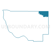
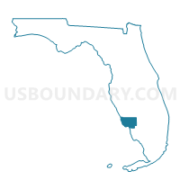
1.1-Voting District, Lee County, Florida
About
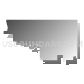
Outline

Summary
| Unique Area Identifier | 554509 |
| Name | 1.1-Voting District |
| County | Lee County |
| State | Florida |
| Area (square miles) | 44.39 |
| Land Area (square miles) | 42.95 |
| Water Area (square miles) | 1.44 |
| % of Land Area | 96.75 |
| % of Water Area | 3.25 |
| Latitude of the Internal Point | 26.74229830 |
| Longtitude of the Internal Point | -81.63605010 |
Maps

Graphs
Select a template below for downloading or customizing gragh for 1.1-Voting District, Lee County, Florida


Neighbors
Neighoring Voting District (by Name) Neighboring Voting District on the Map
- 1.2-Voting District, Lee County, FL
- 1.3-Voting District, Lee County, FL
- 1.4-Voting District, Lee County, FL
- 1.5-Voting District, Lee County, FL
- 120-Voting District, Lee County, FL
- 120.1-Voting District, Lee County, FL
- 16-Voting District (West of Labelle North of River), Hendry County, FL
- 2-Voting District, Lee County, FL
- 23-Voting District (S of River N of SR 80 W of Labelle), Hendry County, FL
- 24-Voting District (S SR 80 & W of SR 29 S), Hendry County, FL
- 26-Voting District, Lee County, FL
- 5-Voting District, Glades County, FL
- 71-Voting District, Charlotte County, FL
Top 10 Neighboring County Subdivision (by Population) Neighboring County Subdivision on the Map
- Lehigh Acres CCD, Lee County, FL (125,214)
- Punta Gorda CCD, Charlotte County, FL (38,241)
- LaBelle CCD, Hendry County, FL (19,246)
- Fort Myers Shores CCD, Lee County, FL (14,137)
- Southwest Glades CCD, Glades County, FL (9,232)
Top 10 Neighboring Place (by Population) Neighboring Place on the Map
- Lehigh Acres CDP, FL (86,784)
- Fort Myers Shores CDP, FL (5,487)
- Alva CDP, FL (2,596)
- Olga CDP, FL (1,952)
- Fort Denaud CDP, FL (1,694)
- Charleston Park CDP, FL (218)
Top 10 Neighboring Unified School District (by Population) Neighboring Unified School District on the Map
- Lee County School District, FL (618,754)
- Charlotte County School District, FL (159,978)
- Hendry County School District, FL (39,140)
- Glades County School District, FL (12,884)
Top 10 Neighboring State Legislative District Lower Chamber (by Population) Neighboring State Legislative District Lower Chamber on the Map
Top 10 Neighboring State Legislative District Upper Chamber (by Population) Neighboring State Legislative District Upper Chamber on the Map
- State Senate District 27, FL (551,555)
- State Senate District 21, FL (529,870)
- State Senate District 39, FL (483,183)
Top 10 Neighboring 111th Congressional District (by Population) Neighboring 111th Congressional District on the Map
Top 10 Neighboring Census Tract (by Population) Neighboring Census Tract on the Map
- Census Tract 3, Hendry County, FL (7,804)
- Census Tract 4.02, Hendry County, FL (7,530)
- Census Tract 2, Glades County, FL (6,870)
- Census Tract 4.01, Hendry County, FL (3,912)
- Census Tract 101, Charlotte County, FL (3,837)
- Census Tract 303, Lee County, FL (2,800)
- Census Tract 301, Lee County, FL (2,477)
- Census Tract 402.09, Lee County, FL (2,383)
- Census Tract 302.03, Lee County, FL (1,533)
- Census Tract 402.08, Lee County, FL (1,319)