


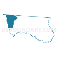
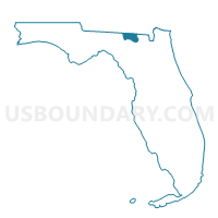
7-Voting District, Hamilton County, Florida
About
Outline

Summary
| Unique Area Identifier | 553429 |
| Name | 7-Voting District |
| County | Hamilton County |
| State | Florida |
| Area (square miles) | 55.28 |
| Land Area (square miles) | 54.56 |
| Water Area (square miles) | 0.73 |
| % of Land Area | 98.68 |
| % of Water Area | 1.32 |
| Latitude of the Internal Point | 30.57295530 |
| Longtitude of the Internal Point | -83.19804340 |
Maps

Graphs
Select a template below for downloading or customizing gragh for 7-Voting District, Hamilton County, Florida


Neighbors
Neighoring Voting District (by Name) Neighboring Voting District on the Map
- 027659 - NANKIN Voting District, Brooks County, GA
- 1-Voting District, Hamilton County, FL
- 18529 - PAPERMILL UNION Voting District, Lowndes County, GA
- 18536 - S LOWNDES REC CENTER Voting District, Lowndes County, GA
- 3-Voting District, Madison County, FL
- 8-Voting District, Hamilton County, FL
- 8-Voting District, Madison County, FL
Top 10 Neighboring County Subdivision (by Population) Neighboring County Subdivision on the Map
- Valdosta CCD, Lowndes County, GA (70,162)
- Madison CCD, Madison County, FL (15,625)
- Lake Park CCD, Lowndes County, GA (7,690)
- Jennings CCD, Hamilton County, FL (4,835)
- Empress CCD, Brooks County, GA (1,117)
Top 10 Neighboring Place (by Population) Neighboring Place on the Map
Top 10 Neighboring Unified School District (by Population) Neighboring Unified School District on the Map
- Lowndes County School District, GA (54,715)
- Madison County School District, FL (19,224)
- Brooks County School District, GA (16,243)
- Hamilton County School District, FL (14,799)
Top 10 Neighboring State Legislative District Lower Chamber (by Population) Neighboring State Legislative District Lower Chamber on the Map
Top 10 Neighboring State Legislative District Upper Chamber (by Population) Neighboring State Legislative District Upper Chamber on the Map
- State Senate District 3, FL (495,081)
- State Senate District 6, FL (451,464)
- State Senate District 8, GA (165,743)
Top 10 Neighboring 111th Congressional District (by Population) Neighboring 111th Congressional District on the Map
- Congressional District 4, FL (744,418)
- Congressional District 1, GA (722,068)
- Congressional District 2, GA (631,973)
Top 10 Neighboring Census Tract (by Population) Neighboring Census Tract on the Map
- Census Tract 114.03, Lowndes County, GA (8,253)
- Census Tract 9602, Hamilton County, FL (4,835)
- Census Tract 116, Lowndes County, GA (3,770)
- Census Tract 1104, Madison County, FL (3,719)
- Census Tract 1101, Madison County, FL (3,235)
- Census Tract 9606, Brooks County, GA (2,605)
Top 10 Neighboring 5-Digit ZIP Code Tabulation Area (by Population) Neighboring 5-Digit ZIP Code Tabulation Area on the Map
- 31601, GA (32,730)
- 31636, GA (9,539)
- 32052, FL (9,223)
- 31643, GA (8,709)
- 32053, FL (3,869)
- 32059, FL (2,377)
- 32350, FL (1,417)