


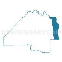
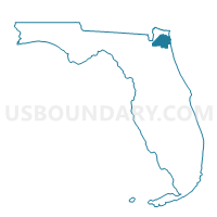
ATL-Voting District, Duval County, Florida
About
Outline

Summary
| Unique Area Identifier | 553005 |
| Name | ATL-Voting District |
| County | Duval County |
| State | Florida |
| Area (square miles) | 69.18 |
| Land Area (square miles) | 0.19 |
| Water Area (square miles) | 68.99 |
| % of Land Area | 0.27 |
| % of Water Area | 99.73 |
| Latitude of the Internal Point | 30.49381210 |
| Longtitude of the Internal Point | -81.42746240 |
Maps

Graphs
Select a template below for downloading or customizing gragh for ATL-Voting District, Duval County, Florida


Neighbors
Neighoring Voting District (by Name) Neighboring Voting District on the Map
- 11-Voting District, Duval County, FL
- 11A-Voting District, Duval County, FL
- 11W-Voting District, Duval County, FL
- 13-Voting District, Duval County, FL
- 13A-Voting District, Duval County, FL
- 13C-Voting District, Duval County, FL
- 13D-Voting District, Duval County, FL
- 13E-Voting District, Duval County, FL
- 13F-Voting District, Duval County, FL
- 13G-Voting District, Duval County, FL
- 13J-Voting District, Duval County, FL
- 13P-Voting District, Duval County, FL
- 204-Voting District, Nassau County, FL
- 404-Voting District, St. Johns County, FL
Top 10 Neighboring County Subdivision (by Population) Neighboring County Subdivision on the Map
- Jacksonville North CCD, Duval County, FL (73,731)
- Jacksonville Beaches CCD, Duval County, FL (54,535)
- Ponte Vedra CCD, St. Johns County, FL (27,140)
- Fernandina Beach CCD, Nassau County, FL (20,452)
Top 10 Neighboring Place (by Population) Neighboring Place on the Map
- Jacksonville city, FL (821,784)
- Jacksonville Beach city, FL (21,362)
- Atlantic Beach city, FL (12,655)
- Neptune Beach city, FL (7,037)
Top 10 Neighboring Unified School District (by Population) Neighboring Unified School District on the Map
- Duval County School District, FL (864,263)
- St. Johns County School District, FL (190,039)
- Nassau County School District, FL (73,314)
Top 10 Neighboring State Legislative District Lower Chamber (by Population) Neighboring State Legislative District Lower Chamber on the Map
Top 10 Neighboring State Legislative District Upper Chamber (by Population) Neighboring State Legislative District Upper Chamber on the Map
Top 10 Neighboring 111th Congressional District (by Population) Neighboring 111th Congressional District on the Map
Top 10 Neighboring Census Tract (by Population) Neighboring Census Tract on the Map
- Census Tract 101.03, Duval County, FL (5,677)
- Census Tract 140.01, Duval County, FL (4,618)
- Census Tract 142.03, Duval County, FL (4,166)
- Census Tract 139.05, Duval County, FL (4,156)
- Census Tract 142.02, Duval County, FL (4,129)
- Census Tract 141.02, Duval County, FL (3,931)
- Census Tract 138, Duval County, FL (2,633)
- Census Tract 207.10, St. Johns County, FL (2,095)
- Census Tract 502.01, Nassau County, FL (1,759)
- Census Tract 9900, Nassau County, FL (0)
Top 10 Neighboring 5-Digit ZIP Code Tabulation Area (by Population) Neighboring 5-Digit ZIP Code Tabulation Area on the Map
- 32034, FL (31,008)
- 32082, FL (28,996)
- 32250, FL (25,356)
- 32233, FL (23,673)
- 32226, FL (15,761)
- 32266, FL (7,037)
- 32227, FL (2,149)